
Aerial Landscape Art: From Imagined Perspectives to Modern Vistas
Aerial landscape art encompasses paintings and visual media that depict or evoke the appearance of the earth from a perspective above it. Typically viewed from a considerable distance, these works simulate the vantage point one would have from an aircraft or spacecraft. While modern iterations often rely on direct observation, many artists utilize aerial photography or maps derived from satellite imagery to compose their works.
The evolution of this genre is intrinsically linked to human technology. While the concept of looking down upon the earth is ancient, the development of true aerial landscape art coincided with the 20th-century advent of transport that allowed humans to physically ascend and observe large-scale landscapes from the sky.
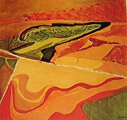
Key Facts
- Definition: Visual art depicting landscapes from an overhead perspective, often simulating views from aircraft or spacecraft.
- Origins: Early forms were map-like and based on imagined viewpoints rather than physical flight.
- Cultural Examples: Ancient Australian Aboriginal "country" landscapes depicted ancestral paths and sacred sites from an aerial view.
- Technological Influence: The 19th-century introduction of balloon travel began the shift toward realistic overhead depictions.
- Modern Sources: Contemporary artists frequently use satellite imagery and aerial photography as primary references.
The Evolution of the Overhead Perspective
Ancient and Imagined Viewpoints
Long before the invention of flight, humans created artworks that utilized a bird's-eye viewpoint—an imagined perspective from above. One of the earliest examples is found in the art of Australian Aborigines, who created "country" landscapes. These works served as vital records, depicting ancestral paths leading to sacred sites and watering holes.
In Europe, this imagined perspective was applied to cartography. Centuries before air travel, Europeans developed maps of entire continents and the globe. These were not based on direct sight, but were constructed using mathematical calculations derived from astronomical relationships and ground surveys.
The Transition to Aerial Townscapes
Before the 20th century, some Western artists produced aerial townscapes focusing on specific precincts or cities. These works often employed a mixed perspective. While the general layout of the town was presented as if seen from directly overhead, key landmarks—such as churches or major civic buildings—were rendered larger than scale and angled as they would appear to a person standing on the ground.
This stylistic choice was functional; because these images served map-like purposes, it was more important for landmarks to be recognizable than for the perspective to be mathematically accurate. A strictly realistic overhead view would have rendered these important buildings unrecognizable to the viewer.
The Impact of Aviation
The 19th century marked a turning point with the introduction of balloon travel. For the first time, pioneering aviators could observe the actual appearance of buildings and terrain from the sky. This shift from imagined perspectives to direct observation paved the way for the realistic aerial landscapes that became more prevalent in the 20th century.
Comparison of Aerial Perspectives in Art
| Era/Style | Perspective Basis | Primary Purpose | Key Characteristic |
|---|---|---|---|
| Ancient/Aboriginal | Imagined | Cultural/Navigational | Ancestral paths and sacred sites |
| Early European Maps | Mathematical/Astronomical | Geographic Record | Continental and global scales |
| Pre-20th Century Townscapes | Mixed Perspective | Functional Identification | Exaggerated landmarks |
| Modern Aerial Art | Direct Observation/Tech | Artistic/Evocative | Based on flight, photos, or satellites |
Frequently Asked Questions
What is aerial landscape art?
It is a genre of visual art that depicts landscapes from a high vantage point, simulating the view from an aircraft, spacecraft, or an imagined overhead position.
Did aerial art exist before airplanes?
Yes, but it was based on imagined perspectives. Examples include ancient Australian Aboriginal "country" landscapes and early European maps created through mathematical calculations.
What is "mixed perspective" in early townscapes?
Mixed perspective is a technique where the overall layout of a scene is shown from above, but individual important buildings are drawn from a ground-level angle and enlarged to ensure they are easily recognizable.
How did balloon travel change aerial art?
Balloon travel in the 19th century allowed artists to see actual overhead views for the first time, leading to more realistic depictions of how landscapes and architecture look from the sky.
What sources do modern aerial artists use?
Modern artists may use direct observation from flight, aerial photography, or maps generated from satellite imagery.