
Blackdown Hills History: From Neolithic Forts to WWII Airbases
The Blackdown Hills possess a rich archaeological tapestry, stretching from the early accumulation of organic materials in the Mesolithic and Neolithic periods to the strategic military installations of the 20th century. Once a landscape of open meadows and scattered woodlands, the region has served as a stronghold for ancient tribes, a center for early industry, and a site of significant military conflict.
Key Facts
- Hembury is believed to have been the capital of the Dumnonii tribe.
- The region's name may derive from the Romano-British iron industry.
- Castle Neroche is a Norman motte-and-bailey castle built on an earlier hill fort.
- Dunkeswell Aerodrome was the only US Navy air base commissioned on UK soil during WWII.
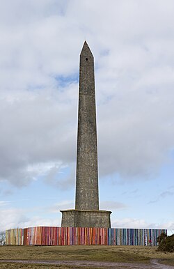
- The Wellington Monument is designed in the shape of a bayonet used by the Duke of Wellington's armies.
Prehistoric and Iron Age Foundations
Early human activity in the Blackdown Hills is evidenced by Bronze Age burial sites, such as Robin Hood's Butts near Otterford. The landscape is particularly noted for its Iron Age hill forts, including Membury Castle, Castle Neroche, and Hembury.
Hembury stands as one of the most significant sites. A Neolithic causewayed enclosure—a prehistoric earthwork consisting of concentric ditches and banks—dating to the late fifth and early fourth millennia BC, it is thought to have been the capital of the Dumnonii tribe. Situated 178 meters (584 ft) above sea level overlooking the River Otter, Hembury gave its name to some of the earliest Neolithic pottery found in southern Britain. Over time, the site evolved, with an Iron Age hill fort and later Roman military occupation built upon it.
Beyond Hembury, fourteen Iron Age hill slope enclosures have been identified across the hills, with prehistoric remains dating back to approximately 100 BC found in Hemyock.
Roman Industry and Medieval Strongholds
During the Romano-British period, the hills became a hub for iron production. Evidence of iron workings at Dunkeswell, radiocarbon dated to the 2nd century, suggests an industrial landscape. Local iron ores were smelted in small bloomeries (primitive furnaces used to produce pure iron) at Hemyock, a practice that continued into the Middle Ages and likely contributed to the name "Blackdown Hills." Other Roman remains include a bath house in Whitestaunton, later excavated by the program Time Team.
In the medieval era, the region saw the rise of Norman architecture. Castle Neroche, located on the northern escarpment at 260 meters (853 ft), is a motte-and-bailey castle—a fortification consisting of a wooden or stone keep on a raised mound (motte) adjacent to an enclosed courtyard (bailey). Likely built by Robert of Mortain in the 11th century, it fell out of use by the 12th century.
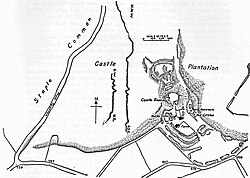
Local folklore links the castle to the "devilstones" near Staple Fitzpaine, large sandstone boulders said to have been thrown by the Devil from the castle. The village name itself is derived from "Stapol" (meaning pillar or post) and the Fitzpaine family, who owned the manor from 1233 to 1393.
Saxon Conquests and the English Civil War
The transition to Saxon rule was marked by conflict. At Simonsburrow, the native Britons fought King Ine's Saxon army. According to the Anglo-Saxon Chronicle, Ine and Nothhelm fought Geraint of Dumnonia in 710, a battle in which John of Worcester records that Geraint was killed. This victory allowed Ine to control Devon, establishing the river Tamar as the border with Dumnonia.
Later, in 1380, King Richard II granted a licence to crenellate—the legal permission to add battlements for fortification—to the Hemyock manor house. Hemyock Castle later became a strategic point during the English Civil War, where it was held for Parliament. After a brutal siege, the castle was slighted (intentionally damaged to prevent further military use). Today, its remaining walls, towers, and moat are a scheduled monument.
From Elizabethan Beacons to Industrialization
To defend against the Spanish Armada, a chain of Elizabethan beacons was established, including one at Culmstock Beacon. This system used fire signals to warn of invasion.
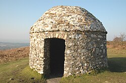
The 17th century saw early, contested attempts at land enclosure. Charles I attempted to enclose parts of the Blackdowns in the 1630s, but faced opposition from commoners and the local lord. While some land was enclosed in 1658, the majority of the hills remained open until 1833.
The Industrial Revolution brought the construction of Coldharbour Mill around 1800. Utilizing the water power of the River Culm, the mill produced wool and yarn until 1981 and now serves as an educational trust.
Modern Landmarks and Military History
The Wellington Monument, completed in 1854 on land belonging to the Duke of Wellington, commemorates the victory at the Battle of Waterloo. The structure's design is inspired by an Egyptian obelisk but shaped like a bayonet.
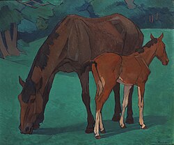
In the early 20th century, the landscape inspired artist Robert Polhill Bevan, who worked in the hills from 1912 to 1925. His angular style captured the patterning of the Bolham valley and Luppitt, and his works are now held in national museums.
During World War II, the region hosted airbases at Upottery, Culmhead, and Dunkeswell. Dunkeswell Aerodrome is particularly notable as the only American Navy air base commissioned on UK soil during the war, having been used by the RAF, USAF, and the USN Fleet Airwing 7.
| Site | Period/Era | Significance |
|---|---|---|
| Hembury | Neolithic/Iron Age | Former capital of the Dumnonii tribe |
| Castle Neroche | Norman (11th C) | Motte-and-bailey castle on an ancient fort |
| Hemyock Castle | Medieval/Civil War | Fortified manor house; Parliamentarian stronghold |
| Coldharbour Mill | Industrial (c. 1800) | Wool and yarn production center |
| Wellington Monument | 19th Century | Bayonet-shaped obelisk celebrating Waterloo |
| Dunkeswell Aerodrome | World War II | Only US Navy air base in the UK |
Frequently Asked Questions
What is the significance of Hembury?
Hembury is a Neolithic causewayed enclosure dating to the late 5th and early 4th millennia BC. It is believed to have been the capital of the Dumnonii tribe and is the namesake for some of the earliest Neolithic pottery in southern Britain.
Why are the hills called the Blackdown Hills?
It is suggested that the name comes from the industrial landscape of the Romano-British period, specifically the iron-working activities and smelting in bloomeries found in areas like Dunkeswell and Hemyock.
What happened to Hemyock Castle during the English Civil War?
The castle was held for Parliament and subjected to a brief, brutal siege. It was eventually slighted, meaning its military value was destroyed, though parts of the walls, towers, and moat remain today.
What is unique about the Wellington Monument's design?
While inspired by an Egyptian obelisk, the monument is specifically shaped like the type of bayonet used by the Duke of Wellington's armies during his campaigns.
Which US military branch used Dunkeswell Aerodrome?
Dunkeswell Aerodrome was used by the RAF, the USAF, and the US Navy's Fleet Airwing 7, making it the only US Navy air base commissioned on UK soil during the Second World War.