
Boquerón Edifice: The Geological History of San Salvador's Volcano
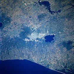
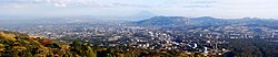
The landscape of the San Salvador Metropolitan Area is defined by its dramatic volcanic surroundings. Positioned between the San Salvador volcano and the Lake Ilopango Caldera, with the Pacific Coast lying to the south, the region is dominated by the Boquerón edifice. This geological structure is not merely a landmark but a complex system of craters and fissures that have shaped the local geography and human history over the last millennium.
The Formation of the Boquerón Edifice
The Boquerón edifice formed between 700 and 1,000 years ago. It developed by filling a former caldera—a large cauldron-like hollow that forms shortly after the emptying of a magma chamber in a volcanic eruption. Evidence of this ancient structure remains today in the form of a crescent-shaped ridge located on the northeast side of the volcano, which serves as a remnant of the original caldera rim.
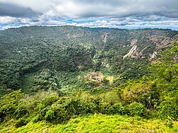
Chemically, the lavas that compose the Boquerón edifice differ from those of the older edifice, containing higher concentrations of iron oxide and alkali elements. Approximately 800 years ago, a violent explosion created the current crater. Known as "Boquerón" (Spanish for "big mouth"), this massive opening measures 1.5 kilometers in diameter and reaches a depth of 500 meters. Today, the fertile soil around the upper walls of the crater is used by local residents for cultivating crops.
Magma Chambers and Fissure Activity
The volcano sits atop a magma chamber characterized by several fissures—linear fractures in the earth's crust through which magma can escape. The most active of these is the northwest (N40W) fissure, which has been responsible for some of the region's most significant eruptive events.
Historical Eruptions
- Loma Caldera Eruption: A devastating event that buried the ancient village of Ceren.
- El Playon Eruption (1658–1671): This eruption buried the town of Nexapa, forcing citizens to relocate to Nejapa. Interestingly, this event is still celebrated annually by the local community.
The 1917 Eruption and Boqueroncito
The most recent volcanic activity occurred in 1917, manifesting as a flank eruption along the N40W fissure. This event had a visible impact on the main crater; the heat caused the internal crater lake to evaporate completely. In its place, a small cinder cone emerged, which was named Boqueroncito.
Key Facts
- Age: Formed between 700 and 1,000 years ago.
- Crater Dimensions: 1.5 km wide and 500 m deep.
- Primary Fissure: The N40W northwest fissure is the most active.
- Recent Activity: The 1917 eruption created the Boqueroncito cinder cone.
- Composition: Lavas are rich in alkali elements and iron oxide.
| Feature | Detail | Significance |
|---|---|---|
| Boquerón Crater | 1.5 km diameter / 500 m depth | Main edifice vent |
| N40W Fissure | Northwest alignment | Source of major flank eruptions |
| Boqueroncito | Cinder cone | Formed during 1917 eruption |
| Crescent Ridge | Northeast side | Remnant of the former caldera rim |
Frequently Asked Questions
What does the name "Boquerón" mean?
Boquerón is a Spanish term meaning "big mouth," referring to the large 1.5 km wide crater at the summit of the volcano.
Which fissure is the most active on the volcano?
The northwest fissure, designated as N40W, has been the most active, leading to significant eruptions such as those at Loma Caldera and El Playon.
What happened to the town of Nexapa?
The town of Nexapa was buried during the El Playon eruption between 1658 and 1671, leading the population to relocate to Nejapa.
How was the Boqueroncito cinder cone formed?
Boqueroncito was formed during the 1917 flank eruption, which also caused the evaporation of the crater lake inside the Boquerón.
What is the chemical difference in the Boquerón edifice lavas?
The lavas of the Boquerón edifice contain more iron oxide and alkali elements compared to the lavas of the older edifice.