
Bramhope History: From Roman Roads to Modern Village
The village of Bramhope possesses a rich historical tapestry that stretches from the earliest British settlements to its current status as a thriving community. Its landscape still holds physical remnants of the ancient civilizations and medieval structures that shaped the region over a millennium ago.
Ancient Foundations and Roman Influence
The earliest evidence of human habitation in the area is a British camp established off Moor Road. Following this early settlement, the Romans left their mark by constructing a strategic road connecting Adel to Ilkley. Today, traces of this Roman infrastructure can still be found in a field located near the Leeds Bradford Airport.
Medieval Ownership and Monastic Land
By the time of the Domesday Book in 1086, Bramhope was recorded as the manor of an Anglo-Saxon thegn (a member of the aristocratic class) named Uchill. The ownership of the manor shifted over the following century, passing to the Percy family in 1095 before being sold to Ralph de Bramhope in 1165.
During the 13th century, the influence of the church grew as monasteries acquired significant portions of the land. These religious institutions established granges—outlying farming estates—specifically for grazing sheep. To transport goods and travel between these granges and Kirkstall Abbey, the monks utilized specific tracks, including those now known as Scotland Lane and Staircase Lane.
Population Shifts and the Black Death
Bramhope's population trajectory was severely impacted by the Black Death between 1348 and 1349. This devastating plague reduced the adult population to just 34 individuals. Recovery was a slow process; the population gradually climbed to approximately 400 by the year 1900, before expanding rapidly in the 20th century to its current estimate of 3,400 residents.
Community Water and the Town Well
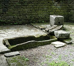
Historically, residents relied on private wells or a centralized town well located at the foot of Northgate, which is now known as Church Hill. This town well serves as a tangible link to the village's past.
In 1991, the Bramhope History Group restored the town well, which is situated opposite St Giles' Church. A commemorative plaque indicates that the well was exposed in 1991, suggesting it may have been lost or buried for a significant period of time.
Key Facts
- Earliest Settlement: A British camp located off Moor Road.
- Roman Legacy: A road from Adel to Ilkley with remnants near Leeds Bradford Airport.
- 1086 Ownership: Held by the Anglo-Saxon thegn, Uchill.
- Monastic Influence: Land used for sheep granges connected to Kirkstall Abbey.
- Plague Impact: The Black Death (1348-49) left only 34 adults in the village.
- Population Growth: Increased from 400 in 1900 to approximately 3,400 today.
| Period/Year | Key Event or Detail | Significance |
|---|---|---|
| Pre-Roman | British camp established | Earliest known settlement |
| Roman Era | Adel to Ilkley road built | Infrastructure development |
| 1086 | Manor held by Uchill | Anglo-Saxon ownership |
| 1348-1349 | Black Death pandemic | Population dropped to 34 adults |
| 1900 | Population reached 400 | Gradual recovery from plague |
| Present | Population approx. 3,400 | Modern village expansion |
Frequently Asked Questions
Who was the first recorded owner of the Bramhope manor?
In 1086, the manor of Bramhope was owned by an Anglo-Saxon thegn named Uchill.
How did the monasteries use the land in Bramhope?
In the 13th century, monasteries owned much of the land and operated granges for grazing sheep, using tracks like Scotland Lane and Staircase Lane to reach Kirkstall Abbey.
What happened to the population during the 14th century?
The Black Death of 1348-49 caused a drastic decline in the population, leaving only 34 adults in the village.
Where is the town well located and when was it restored?
The town well is located opposite St Giles' Church (formerly at the foot of Northgate/Church Hill) and was restored by the Bramhope History Group in 1991.
Are there any Roman remains in the area?
Yes, traces of a Roman road that ran from Adel to Ilkley can still be found in a field near Leeds Bradford Airport.