
Fuiay: The Uninhabited House Island of the Outer Hebrides
Tucked away in the rugged beauty of the Outer Hebrides lies Fuiay (Scottish Gaelic: Fùidheigh), a serene and uninhabited island that whispers stories of a bygone era. Located within the Sound of Barra, Fuiay is part of a cluster of ten islands designated as a Site of Community Importance for conservation, ensuring the preservation of its unique natural landscape.
The island is positioned immediately west of Flodday and approximately 1.5 kilometers southwest of Hellisay, with the larger island of Barra situated across the waters of North Bay.
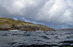
Key Facts
- Location: Sound of Barra, Outer Hebrides, Scotland.
- Area: 84 hectares (approximately 210 acres).
- Highest Point: 107 meters (351 feet).
- Population: 0 (Uninhabited since circa 1850).
- Administration: Comhairle nan Eilean Siar.
- Etymology: Likely derived from Norse for "house island."
Geography and Natural Landscape
Fuiay is a modest landmass covering 84 hectares, ranking 159th in area among the region's islands. Its terrain is characterized by an unnamed highest eminence that reaches an elevation of 107 meters, providing a vantage point over the surrounding Atlantic waters.
The waters surrounding the island are complex and varied. To the northwest, the sea is dotted with numerous skerries (small, rocky islets) and islets. For those navigating the area, a sheltered anchorage exists north of Rubh' an Aiseig, protected by the islets of Sgeirislum to the west and Eilean Sheumais to the east. Further north, in the Sound of Hellisay, lies the larger islet of Garbh Lingeigh.
Regional Context
Fuiay is part of a wider archipelago of uninhabited islands off the northeast coast of Barra, which includes neighboring islands such as Orosay, Fuday, and Gighay.
History and Human Presence
While Fuiay is currently silent, it was once home to a small community. In the early 19th century, the island featured six households arranged along a "street" at Rubh' an Aiseig, which translates from English as "ferry headland," located in the northwest portion of the island.
Evidence of the inhabitants' ingenuity remains in the form of a tidal inlet at the headland, which researchers believe may have served as an effective fish-trap for the residents. However, this small settlement was short-lived, and the island has remained uninhabited since approximately 1850.
Etymology and Naming
The origin of the name Fuiay reflects the multicultural history of the Hebrides. It is most likely derived from the Norse term for "house island." An alternative theory suggests a linguistic blend, combining the Gaelic word bhuidhe (meaning "yellow") with the Norse øy (meaning "island").
| Feature | Detail |
|---|---|
| OS Grid Reference | NF740022 |
| Coordinates | 57°00′N 7°22′W |
| Total Area | 84 ha (210 acres) |
| Max Elevation | 107 m (351 ft) |
| Current Population | 0 |
| Council Area | Comhairle nan Eilean Siar |
Frequently Asked Questions
Where is Fuiay located?
Fuiay is located in the Sound of Barra within the Outer Hebrides of Scotland, situated west of Flodday and southwest of Hellisay.
Is anyone currently living on Fuiay?
No, the island is currently uninhabited. It has been devoid of a permanent population since around 1850.
What does the name Fuiay mean?
The name likely comes from the Norse words for "house island," though it may also be a combination of the Gaelic word for "yellow" (bhuidhe) and the Norse word for "island" (øy).
What is the highest point on the island?
The highest point on Fuiay is an unnamed eminence that reaches an elevation of 107 meters (351 feet).
What historical structures are found on the island?
The island contains the remains of six households that were once located along a street at Rubh' an Aiseig, as well as a tidal inlet that likely functioned as a fish-trap.