
Highland Boundary Fault: Tectonic History and Geological Composition
The Highland Boundary Fault is one of Scotland's most significant geological features, serving as a dramatic dividing line between the rugged Highlands to the north and the softer landscapes of the Central Lowlands to the south. This fault system is not merely a crack in the earth but a complex record of ancient collisions and tectonic shifts that shaped the British Isles.
Key Facts
- Active Periods: Primarily active during the Grampian (Early Ordovician) and Acadian (Middle Devonian) orogenies.
- Vertical Displacement: Allowed the Midland Valley to descend as a rift by up to 4,000 meters (13,000 ft).
- Lithological Contrast: Separates hard Precambrian/Cambrian metamorphic rocks from softer Devonian and Carboniferous sedimentary rocks.
- Recent Activity: The 2003 Aberfoyle earthquake occurred at a depth of 4 km along an oblique sinistral strike-slip fault.
- Width of Border Complex: The Highland Border Complex forms a discontinuous zone up to 1.2 kilometers wide.
Tectonic Evolution and Controversy
The history of the Highland Boundary Fault is tied to the Caledonian orogeny, a massive mountain-building event. Geologists believe the fault was active during two primary phases: the Grampian orogeny in the Early Ordovician and the Acadian orogeny in the Middle Devonian. Initially, the fault functioned as a major rift, causing the Midland Valley to drop significantly. Over time, this vertical movement transitioned into horizontal shear.
Despite its prominence, the exact nature of the fault remains a subject of tectonic controversy. Because there is little evidence of a continuous fault plane on the surface, researchers have proposed various interpretations. It has been described as a graben-bounding normal fault, a northwest-dipping reverse fault, a terrane boundary, or a major sinistral strike-slip fault (a fault where the blocks move horizontally past each other to the left).
Modern seismic data has provided new clarity. Analysis of the 2003 Aberfoyle earthquake revealed a hypocentre at a depth of 4 km, caused by an oblique sinistral strike-slip fault with normal movement, dipping at 65° NW.
Associated Lithology and Rock Formations
The fault marks a stark contrast in the types of rocks found on either side, creating a distinct geological boundary.
The Northern and Western Sector
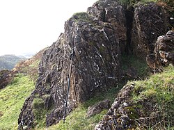
To the north and west, the landscape is dominated by hard Precambrian and Cambrian metamorphic rocks. These include the Dalradian Supergroup—marine deposits that were transformed into schists, phyllites, and slates—and the Highland Border Ophiolite suite.
The Dalradian Supergroup underwent polyphase deformation. The oldest rocks, known as the Grampian Group, were metamorphosed around 750 Ma. Deposition continued until 590 Ma, eventually transforming into greenschist facies (a medium-grade metamorphic rock) during the Proterozoic and Ordovician periods.
Additionally, gravity and magnetic modeling have confirmed an extensive ophiolite suite (sections of the Earth's oceanic crust and upper mantle). This obducted ophiolite is continuous for several kilometers on both sides of the fault and appears to have been only slightly displaced vertically.
The Southern and Eastern Sector
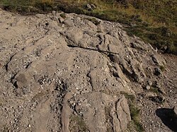
To the south and east, the geology shifts to the Old Red Sandstone, consisting of conglomerates and sandstones from the Devonian and Carboniferous periods. These are softer sedimentary rocks compared to their northern counterparts. In the northeast segment of the fault, the dip of the Old Red Sandstone changes abruptly from 20° to near-vertical, exposing the basement rock.
The Highland Border Complex
Situated between these two major zones is the Highland Border Complex. This is a weakly metamorphosed sedimentary sequence featuring lavas, limestones, mudstones, conglomerates, and sandstones. This complex appears discontinuously along the fault line in a zone up to 1.2 kilometers wide.
Geological Summary Table
| Region/Unit | Rock Types | Age/Period | Key Characteristics |
|---|---|---|---|
| North/West (Dalradian) | Schists, Phyllites, Slates | Precambrian to Early Paleozoic | Hard metamorphic rocks; polyphase deformation |
| Highland Border Ophiolite | Oceanic crust/mantle rocks | Various | Obducted suite; minimal vertical displacement |
| Highland Border Complex | Lavas, Limestones, Mudstones | Various | Weakly metamorphosed; 1.2 km wide zone |
| South/East (Old Red Sandstone) | Conglomerates, Sandstones | Late Silurian to Carboniferous | Softer sedimentary red beds and lacustrine deposits |
Frequently Asked Questions
What caused the Highland Boundary Fault to form?
The fault was formed during the Caledonian orogeny, specifically during the Grampian and Acadian orogenic events, which involved massive tectonic collisions and crustal movements.
How deep was the 2003 Aberfoyle earthquake?
The earthquake had a hypocentre located at a depth of 4 km (approximately 2.5 miles).
What is the difference between the rocks north and south of the fault?
The north consists of hard, ancient metamorphic rocks like those in the Dalradian Supergroup, while the south consists of softer, younger sedimentary rocks known as the Old Red Sandstone.
What is an ophiolite suite in the context of this fault?
An ophiolite suite is a section of the Earth's oceanic crust and upper mantle that has been uplifted and exposed on land (obducted). In this region, it is found overlying the Dalradian metasedimentary rocks.
Why is the exact nature of the fault still debated?
The precise nature is unknown because there is very little evidence of a continuous fault plane visible on the surface, leading to multiple interpretations ranging from a normal fault to a strike-slip fault.