
Jones Bridge: The History and Ruins of a Chattahoochee River Landmark
Spanning the Chattahoochee River, the Jones Bridge (originally known as Jones Ferry) stands as a silent witness to the region's transit history. From its operational peak in the early 20th century to its gradual decay and eventual collapse, the bridge offers a fascinating glimpse into local heritage and a mysterious tale of theft.
The Rise and Fall of Jones Bridge
The bridge served as a vital crossing over the Chattahoochee River from 1904 until 1922. By the 1930s, the structure had fallen into significant disrepair. However, the most unusual chapter of its history involves the disappearance of its structural components.
While many accounts suggest that half of the bridge was stolen during the 1940s, aerial photography provides a different timeline. Images from 1955 show both trusses—the supporting frameworks of the bridge—still intact. By 1960, they had vanished. Local residents reportedly witnessed workers cutting the bridge, unaware that the operation was unauthorized until the theft was complete. To this day, the culprits have never been identified or apprehended.
The remnants of the structure persisted for decades until the bridge finally collapsed into the river on January 25, 2018.
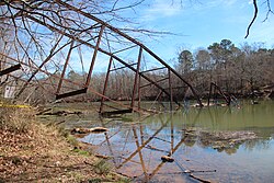
Visiting the Ruins Today
The remains of Jones Bridge are accessible to the public via two adjacent parks or by navigating the river via kayak, canoe, or small boat.
Jones Bridge Park
Located on the east side of the river in Peachtree Corners, Gwinnett County, this park is the most convenient option for visitors. It provides the best vantage points for photographing the ruins and offers a wide array of amenities, including parking, restrooms, a playground, volleyball courts, grills, and easy river access via stairs and a ramp.
Chattahoochee River National Park - Jones Bridge Unit
Situated on the west side of the river in Johns Creek, Fulton County, this unit is tailored for hikers and boaters. While it provides basic parking and restrooms, its primary draw is the boat launch area and extensive trail system. To reach the bridge ruins from this side, visitors must follow the river trails upstream for approximately 1/4 to 1/2 mile. Note that while the site is listed as wheelchair accessible, accessibility is extremely limited beyond the parking area in the Jones Bridge Unit.
Key Facts
- Operational Years: 1904–1922.
- Theft Timeline: Aerial photos indicate the trusses were stolen between 1955 and 1960.
- Final Collapse: January 25, 2018.
- Location: Spans the border of Gwinnett County (Peachtree Corners) and Fulton County (Johns Creek).
- Access: Reachable via Jones Bridge Park, Chattahoochee River National Park, or by boat.
| Feature | Jones Bridge Park | CNP - Jones Bridge Unit |
|---|---|---|
| County | Gwinnett (Peachtree Corners) | Fulton (Johns Creek) |
| Best For | Photography & Families | Boating & Hiking |
| Amenities | Playground, Grills, Volleyball | Boat Launch, Long Trails |
| Bridge Access | Easy/Direct | 1/4 to 1/2 mile hike upstream |
Frequently Asked Questions
When did Jones Bridge collapse?
The bridge finally collapsed into the Chattahoochee River on January 25, 2018.
When was the bridge stolen?
Although some reports claim the 1940s, aerial photography shows the trusses were present in 1955 and gone by 1960, placing the theft between those years.
Which park is better for viewing the bridge?
Jones Bridge Park in Peachtree Corners offers the best views and the easiest access for those wishing to see or photograph the ruins.
Is the Jones Bridge Unit of the National Park wheelchair accessible?
While the site is listed as wheelchair accessible, accessibility is extremely limited once you leave the parking area.
How can I reach the bridge by water?
The ruins are visible to those traveling down the Chattahoochee River by small boat, canoe, or kayak.