
Keihanshin Metropolitan Area: Geography, Population, and Urban Definitions
The Keihanshin region represents one of Japan's most significant urban agglomerations, encompassing the interconnected cities of Osaka, Kyoto, and Kobe. This vast network of municipalities creates a complex economic and social hub, defined by high population densities and extensive commuting patterns. Because the region is so expansive, different statistical bodies use varying methodologies to define its boundaries and scale.
At its broadest level, the region integrates the metropolitan areas of Osaka, Kobe, Kyoto, and Himeji, along with several periurban areas—regions transitioning from urban to rural—particularly in eastern Shiga Prefecture.
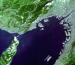
Defining the Major Metropolitan Area (MMA)
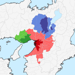
The Japan Statistics Bureau utilizes the Major Metropolitan Area (MMA) definition to categorize urban clusters. An MMA is defined as a group of municipalities where at least 1.5% of the resident population aged 15 and older commute to a designated core city for work or school. When multiple designated cities have overlapping outlying areas, they are merged into a single multi-core area.
For the Keihanshin MMA, the designated core cities identified in the 2005 census were Osaka, Kobe, and Kyoto, with Sakai subsequently becoming a designated city. As of 2015, this entire region spanned 13,228 square kilometers (5,107 square miles) with a total population of 19,302,746.
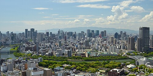
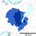
Alternatively, the Statistics Bureau may use a distance-based measure. This defines the metropolitan area as all municipalities located entirely or mostly within 50 kilometers (31 miles) of the Osaka Municipal Office. Under this specific metric, the population was recorded as 16,260,117 in 2015.
![Keihanshin MMA as of 2015[update] with core cities in dark blue: Osaka, Sakai, Kyoto, Kobe](/images/1c/06/1c06ac85be3ea45e504dcbeb4156ae82aee69e14fe290c04caba2938c2c697c7.png)
The Urban Employment Area (UEA) Framework
Developed by the Faculty of Economics at the University of Tokyo, the Urban Employment Area (UEA) is a definition similar to the Metropolitan Statistical Area used in the United States. This model relies on the concept of a Densely Inhabited District (DID), which is a group of census enumeration districts with a population density of 4,000 or more persons per square kilometer.
The UEA classification is split into two categories based on the core area's DID population:
- Metropolitan Employment Area (MEA): A core area with a DID population of 50,000 or more.
- Micropolitan Employment Area: A core area with a DID population of less than 50,000.
Outlying areas are included if 10% or more of their employed population works in the core or another outlying area. To avoid overlap, an outlying area is assigned to the core area with the highest commuter ratio.
Detailed Breakdown of Metropolitan Employment Areas
Osaka MEA
The Osaka MEA is the largest in the region, ranking second in Japan. As of 2015, it had a population of 12,078,820 and a nominal GDP of 45.4 trillion Japanese yen (2010). Its core cities include Osaka, Sakai, Kadoma, and Higashiōsaka.
The area extends across several prefectures:
- Osaka Prefecture: The entire prefecture.
- Hyōgo Prefecture: Amagasaki, Nishinomiya, Ashiya, Itami, Takarazuka, Kawanishi, and Sanda.
- Nara Prefecture: Nara, Tenri, Yamatotakada, Yamatokōriyama, Kashihara, Sakurai, Ikoma, Kashiba, and Katsuragi.
- Other: Yawata (Kyoto) and Hashimoto (Wakayama).
Kyoto MEA
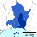
With a 2015 population of 2,801,044, the Kyoto MEA is centered around the core cities of Kyoto and Kusatsu. It includes southern Kyoto Prefecture (Uji, Kameoka, Joyo, Muko, Nagaokakyo, Kyotanabe) and southwestern Shiga Prefecture (Otsu, Moriyama).
Kobe MEA
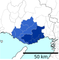
The Kobe MEA had a population of 2,565,501 in 2015, with Kobe serving as the core city. Its outlying areas include southern Hyōgo (Akashi, Kakogawa, Takasago, Miki, and Ono) and southeastern Hyōgo (Amagasaki, Nishinomiya, Ashiya, Itami, Takarazuka, Kawanishi, and Sanda).
Himeji and Wakayama MEAs
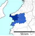
Smaller but significant, the Himeji MEA (population 773,389) is centered on Himeji and includes Aioi, Tatsuno, and several southern Hyōgo cities. The Wakayama MEA (population 569,758) is centered on Wakayama and includes Kainan in the northwestern part of the prefecture.
Key Facts
- Total Population: 19,302,746 (Keihanshin MMA, 2015).
- Total Area: 13,228 square kilometers.
- Osaka MEA Rank: 2nd most populous metropolitan area in Japan.
- Osaka MEA GDP: 45.4 trillion Japanese yen (2010).
- Core Cities: Osaka, Kobe, Kyoto, and Sakai.
- UEA Threshold: A Metropolitan Employment Area requires a core DID population of at least 50,000.
| Employment Area (MEA) | Core City/Cities | Population (2015) | Primary Prefectures |
|---|---|---|---|
| Osaka | Osaka, Sakai, Kadoma, Higashiōsaka | 12,078,820 | Osaka, Hyōgo, Nara, Kyoto, Wakayama |
| Kyoto | Kyoto, Kusatsu | 2,801,044 | Kyoto, Shiga |
| Kobe | Kobe | 2,565,501 | Hyōgo |
| Himeji | Himeji | 773,389 | Hyōgo |
| Wakayama | Wakayama | 569,758 | Wakayama |
Frequently Asked Questions
What is the difference between an MMA and an MEA?
A Major Metropolitan Area (MMA) is defined by the Japan Statistics Bureau based on a 1.5% commuting threshold to a core city. A Metropolitan Employment Area (MEA) is defined by the University of Tokyo based on Densely Inhabited Districts (DID) and a 10% employment commuting ratio.
Which city serves as the primary core for the largest MEA in the region?
Osaka is the primary core city for the Osaka MEA, which is the largest in the region and the second largest in all of Japan.
What is a Densely Inhabited District (DID)?
A DID is a group of census enumeration districts that have a population density of 4,000 or more persons per square kilometer.
How many people live within 50km of the Osaka Municipal Office?
As of 2015, the population within this specific 50-kilometer radius was 16,260,117.
Which prefectures are involved in the Keihanshin region?
The region spans several prefectures, including Osaka, Kyoto, Hyōgo, Nara, Wakayama, and Shiga.