
Lima District: Governance, Geography, and Urban Layout
The district of Lima serves as the political and administrative heart of the Peruvian capital. It is most notably the site of the Municipal Palace, the seat of the Metropolitan Municipality of Lima, which manages the city's overarching governance.
Key Facts
- Current Mayor: Rafael López Aliaga (since 2023).
- Administrative Center: The Municipal Palace.
- Population: 268,352 residents as of 2017.
- Global Reach: Twinned with 24 cities across Asia, Europe, and the Americas as of 2025.
- Key Landmark: Home to the National Stadium of Peru.
Urban Subdivisions and Neighborhoods
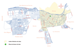
The district is organized into several distinct neighborhoods and a single populated center that is coterminous with the district boundaries.
Central Lima (Cercado de Lima)
Also known as the Damero de Pizarro, Central Lima is bounded by Huánuco Street to the east and Alfonso Ugarte Avenue to the west. The area is bisected by the pedestrian Union Street, which serves as the dividing line between the East and West sides. In this area, city blocks (cuadras) are numbered starting at 100, with the first digit changing at each subsequent block.
Traffic is primarily managed via two main thoroughfares: Tacna Avenue on the West side and Abancay Avenue on the East, both located four blocks away from Union Street. The Main Square is situated on block 2 of Union Street, directly facing the Government Palace and the Metropolitan Municipality of Lima (City Hall).
Barrios Altos and Chinatown
Located to the east of the center, Barrios Altos is home to the district's oldest structures and remnants of the colonial city walls. Its eastern border with El Agustino is marked by two cemeteries: El Ángel and Presbítero Maestro. Adjacent to this area to the southwest is the city's Chinatown, which dates back to the mid-1800s.
Monserrate and Santa Beatriz
Monserrate lies west of Tacna Avenue, bordered by Emancipación and Alfonso Ugarte avenues. To the south is Santa Beatriz, a residential area featuring the Parque de la Reserva and Arequipa Avenue, a tree-lined boulevard.
Santa Beatriz is a hub for Peruvian media, housing the state network TV Perú and the leading private networks, América Televisión (Channel 4) and Panamericana Televisión (Channel 5). It is also the location of the National Stadium of Peru, the primary football stadium for both the city and the country.
The Industrial Area
Extending west into the neighboring Callao Region, the Industrial Area consists of large blocks and factories, serving as the primary industrial belt for the city and nation. This zone also encompasses the University City of the National University of San Marcos.
District Statistics
The district is characterized by a single urban populated center. Residential clusters are particularly prominent at the northern and southern edges, specifically where the district borders San Miguel, Pueblo Libre, and the Bellavista District of the Callao Region.
| Code | Name | Type | Total Population | Total Housing |
|---|---|---|---|---|
| 0001 | Lima | Urban | 268,352 | 91,506 |
Frequently Asked Questions
Who is the current mayor of Lima?
As of 2023, the incumbent mayor is Rafael López Aliaga.
What is the Damero de Pizarro?
The Damero de Pizarro is another name for Central Lima (Cercado de Lima), the central urban core of the district.
Where is the National Stadium of Peru located?
The National Stadium of Peru is located in the Santa Beatriz neighborhood.
Which major media networks are based in Santa Beatriz?
Santa Beatriz hosts the state network TV Perú, as well as private networks América Televisión (Channel 4) and Panamericana Televisión (Channel 5).
What defines the borders of the Industrial Area?
The Industrial Area is an industrial belt located toward the west of the district that extends into the Callao Region and includes the University City of the National University of San Marcos.