
Lymm Transport and Infrastructure: From Historic Canals to Modern Motorways
Lymm is a village defined by its strategic location and a rich history of movement. From the industrial era of canals and railways to the high-speed connectivity of modern motorways, the village serves as a vital link between major hubs like Warrington and Altrincham. Whether by road, water, or trail, Lymm's infrastructure reflects a transition from heavy industry to leisure and regional commuting.
Key Facts
- Major Road Access: Located within 3 miles (4.8 km) of the M56 and M6 motorways.
- Waterways: The village is intersected by the Bridgewater Canal and bordered by the River Bollin.
- Railway History: The local line closed to passengers in 1962 as part of the Beeching cuts.
- Modern Leisure: The former railway line now forms part of the Trans Pennine Trail.
- Local Landmark: Lymm Dam was constructed in 1824 to facilitate the building of the A56.
Road and Bus Connectivity
Lymm is exceptionally well-connected by road. The Lymm Interchange, where the M56 (junctions 7, 8, and 9) and M6 (junctions 19 and 20) meet the A50, is a central transport node. This area is home to the Poplar 2000 services, a frequently used truck stop for long-haul logistics.
For local travel, the A56 passes just south of the village, providing a direct link to the nearby towns of Warrington and Altrincham. Public transport is supported by the Bee Network franchise, with services operated by Diamond North West and Warrington's Own Buses. The CAT5/5A bus routes offer frequent weekday and Saturday connections to these neighboring towns.
Waterways and Natural Borders
Water has played a pivotal role in Lymm's development. The Bridgewater Canal flows directly through the center of the village, serving as a reminder of the region's industrial heritage.
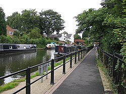
Further north, the Manchester Ship Canal and the River Mersey define the landscape. To the east, the River Bollin marks the boundary between Lymm, Warburton, and the Borough of Trafford. One of the village's most popular tourist spots, Lymm Dam, was created in 1824. This artificial body of water was engineered specifically to allow for the construction of the Stockport–Warrington Road, known today as the A56.
The Evolution of Lymm's Railways
Rail transport once flourished in the area. The Lymm railway station opened on November 1, 1853, as part of the Warrington and Altrincham Junction Railway. Additionally, a station at Heatley on Mill Lane served the transport of lead and salt.
The network extended east via Dunham into Broadheath and the Manchester network, while the western route led to Warrington via Latchford and the tar processing facilities on Loushers Lane, eventually reaching Bank Quay Low Level. However, the line fell victim to the Beeching cuts—a major restructuring of British railways—and closed to passengers on September 10, 1962. While it officially closed to all traffic on July 7, 1985, it remained operational for a short period thereafter before the tracks and sleepers were removed.
Today, residents rely on nearby stations at Glazebrook, Birchwood, Warrington Central, Knutsford, and Altrincham Interchange.
Cycleways and Heritage
The legacy of the railway lives on through the Trans Pennine Trail, a long-distance path that utilizes the old railway corridor. A ranger station is located at Statham, near the village center, to support trail users.
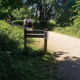
To ensure the trail remains accessible year-round, upgrade work began in 2022 to install all-weather surfaces for walkers and cyclists.
The village continues to celebrate its transport history through the Lymm Historic Transport Day. This annual summer festival, held on the May Queen field, showcases a variety of vintage vehicles and canal boats.
Transport Summary
| Mode | Key Infrastructure / Route | Status / Note |
|---|---|---|
| Motorway | M56, M6, A50 (Lymm Interchange) | Active; includes Poplar 2000 services |
| Bus | CAT5/5A (Bee Network) | Active; connects Warrington and Altrincham |
| Waterway | Bridgewater Canal | Active; passes through village center |
| Railway | Warrington and Altrincham Junction Railway | Closed (Passengers 1962, All traffic 1985) |
| Cycleway | Trans Pennine Trail | Active; converted from old railway line |
Frequently Asked Questions
What is the Lymm Interchange?
The Lymm Interchange is the junction where the M56 (junctions 7, 8, and 9) and M6 (junctions 19 and 20) motorways meet the A50. It is also the site of the Poplar 2000 truck stop services.
Why was Lymm Dam built?
Lymm Dam was constructed in 1824 to facilitate the building of the Stockport–Warrington Road, which is now the A56.
When did the railway service in Lymm end?
Passenger services ended on September 10, 1962, as part of the Beeching cuts. The line officially closed to all traffic on July 7, 1985.
What can be found on the site of the old railway today?
The former railway line has been converted into a section of the Trans Pennine Trail, providing a route for cyclists and walkers, including all-weather surfaces added during 2022 upgrades.
Which bus companies operate in Lymm?
Buses are operated by Warrington's Own Buses and Diamond North West under the Bee Network franchise.