
Orinoco River: South America's Mighty Waterway
The Orinoco River is one of the most significant hydrological systems in South America. Stretching 2,140 km (1,330 mi), it serves as a vital artery for both Venezuela and Colombia. Its massive drainage basin, often referred to as the Orinoquia, covers approximately 1,000,000 km² (390,000 sq mi), with 65% of the area located in Venezuela and 35% in Colombia.
Due to exceptionally high precipitation across its catchment area—averaging 2,300 millimetres per are—the Orinoco is the third largest river in the world by discharge volume, pumping an average of 39,000 m³/s into the Atlantic Ocean at its delta.
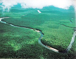
Key Facts
- Total Length: 2,140 km (1,330 mi).
- Global Rank: 3rd largest river by water discharge volume.
- Basin Size: ~1,000,000 km² (390,000 sq mi).
- Maximum Depth: 100 m (330 ft).
- Etymology: Derived from the Warao word for "a place to paddle."
- Primary Countries: Venezuela and Colombia.
Geography and River Course
The Orinoco's journey from the highlands to the ocean is divided into four distinct geographical sections:
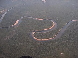
Upper Orinoco
Spanning 286 km (178 mi), this section begins at the hydrological source in Cerro Delgado-Chalbaud (1,047 m elevation) and flows northwesterly through a mountainous landscape until it reaches the Raudales de Guaharibos rapids.
Middle Orinoco
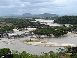
This 805 km (500 mi) stretch is split into two parts. The first flows westward to the confluence of the Atabapo and Guaviare rivers. The second flows northward along the Colombia-Venezuela border, where granitic upwellings from the Guiana Shield prevent the formation of a wide flood plain, ending at the Atures rapids.
Lower Orinoco
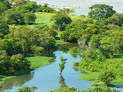
The Lower Orinoco extends 959 km (596 mi) and is characterized by a well-developed alluvial plain—a flat landform created by the deposition of sediment over time. It flows northeast from the Atures rapids toward Piacoa.
Delta Amacuro
The river concludes in a massive delta, approximately 200 km (120 mi) long and up to 370 km (230 mi) wide. This complex network of hundreds of waterways covers 41,000 km² of swampy forests before emptying into the Gulf of Paria and the Atlantic Ocean.
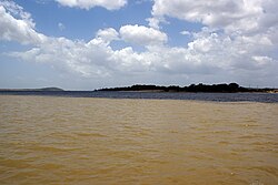
![Orinoco at its confluence with the Caroní River (lower left)[18]](/images/93/20/932017665aceacabe6386277f939c84539ceb7ff8a9293c7310cfe409ba1b3bd.jpg)
Hydrology and Tributaries
The Orinoco is fed by a vast network of tributaries. Major left-bank tributaries include the Apure, Meta, Guaviare, and Arauca. Right-bank tributaries include the Caroní, Caura, and Ventuari. A unique feature of this system is the Casiquiare canal, a natural link that connects the Orinoco system with the Amazon river system.
| Feature | Detail |
|---|---|
| Hydrological Source | Cerro Delgado-Chalbaud, Venezuela (1,047 m) |
| Geographical Source | Cordillera Oriental, Colombia (3,080 m) |
| Mouth | Atlantic Ocean (Delta Amacuro) |
| Average Discharge (Delta) | 39,000 m³/s |
| Maximum Depth | 100 m |
History and Exploration
The mouth of the Orinoco was first documented by Christopher Columbus on August 1, 1498. Throughout the 16th century, German expeditions led by Ambrosius Ehinger and others explored the eastern Llanos. In 1595, Sir Walter Raleigh sailed the river in search of the mythical city of El Dorado.
Modern exploration continued into the 20th century. In 1951, a French-Venezuelan expedition led by Frank Risquez Iribarren discovered the river's source. In 1968, a BBC-filmed expedition used a hovercraft to travel from the Amazon to the Orinoco via the Casiquiare canal.
Ecology and Economy
The basin is a biodiversity hotspot, hosting over 1,000 fish species, 15% of which are endemic (found nowhere else). The most dominant orders are Characiformes and Siluriformes, including the cardinal tetra and black spot piranha.
Economically, the river is a vital transport route. Ocean-going ships can reach as far as Ciudad Bolívar via dredging. The region is also rich in minerals; in 1926, massive iron ore deposits were discovered near the delta at El Florero, leading to large-scale mining operations after World War II.
Recreation and Culture
The Orinoco is a hub for endurance sports. Since 1973, the Internacional Rally Nuestros Rios son Navegables has seen motonautical competitors race over 1,200 km. Additionally, the Paso a Nado Internacional de los Rios Orinoco–Caroní is an annual international swim meet held every April.
Frequently Asked Questions
How long is the Orinoco River?
The Orinoco River has a total length of 2,140 km (1,330 mi).
Which countries does the Orinoco River flow through?
The river and its drainage basin are located in Venezuela and Colombia.
What is the Casiquiare canal?
The Casiquiare canal is a natural waterway that connects the Orinoco River system with the Rio Negro, which is part of the Amazon river system.
Why is the Orinoco's water discharge so high?
The high discharge volume is due to the intense precipitation throughout its catchment area, which averages 2,300 millimetres per are.
What are the main economic uses of the river?
The river is used for commercial navigation, cargo transport via steamers, and the extraction of rich iron ore deposits found near the delta.