
QZSS Positioning Augmentation and Satellite Services
The Quasi-Zenith Satellite System (QZSS) is a specialized satellite constellation designed primarily to enhance the availability of the Global Positioning System (GPS) in Japan. In densely populated urban environments—often referred to as "urban canyons"—tall buildings frequently block satellite signals. QZSS solves this by ensuring satellites remain at very high elevation angles, allowing receivers to maintain a lock on positioning signals even in restricted views.
Beyond increasing availability, QZSS serves as a performance enhancer, improving the accuracy and reliability of GPS-derived navigation. To ensure seamless integration, QZSS transmits signals compatible with GPS L1C/A, as well as modernized GPS L1C, L2C, and L5 signals, minimizing the need for hardware changes in existing GPS receivers.
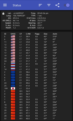
Key Facts
- Primary Goal: Increase GPS availability in Japan's urban canyons via high-elevation satellites.
- Interoperability: Compatible with GPS L1C/A, L1C, L2C, and L5 signals.
- Augmentation: Provides sub-meter and centimeter-level accuracy through specialized correction signals.
- Multi-GNSS Support: Augments multiple constellations, including GPS, GLONASS, Galileo, and BeiDou.
- Safety Services: Includes the DC Report for broadcasting disaster and crisis management information.
PNT and Core Navigation Services
The Positioning, Navigation, and Timing (PNT) service acts as a complement to GPS by essentially providing additional satellites. QZSS satellites synchronize their clocks with GPS satellites and broadcast on the same frequency bands (L1C/A, L1C, L2C, and L5) using largely interoperable formats.
Multi-System Integration
The L1C and L2C messages include time differences for GPS, GLONASS, and BeiDou, facilitating the simultaneous use of multiple satellite navigation systems. Additionally, Block III satellites utilize L1C/B, which adds a square wave subcarrier modulation to the standard L1C/A signal.
Ionospheric Corrections
To account for atmospheric interference, QZSS provides two sets of ionospheric parameters: one tailored for a rectangular area enclosing Japan and another for a much broader global area.
Advanced Augmentation Services
QZSS offers several tiers of augmentation to move beyond standard GPS accuracy, ranging from sub-meter to centimeter-level precision.
Sub-Meter and Centimeter Accuracy
- SLAS (Sub-meter Level Augmentation Service): Transmitted on the L1S signal, SLAS provides differential GPS data regarding pseudorange errors at monitoring stations. This includes the Michibiki Satellite-based Augmentation Service (MSAS), which uses an EGNOS-like state-space data structure.
- CLAS (Centimeter Level Augmentation Service): Operating on the L6 band (signal L62, message L6D), CLAS provides high-precision positioning compatible with Galileo's High Accuracy Service (HAS). It delivers state-space corrections, SBAS availability, and ionospheric/tropospheric data.
Precise Point Positioning (PPP)
The MADOCA-PPP (Multi-GNSS Advanced Orbit and Clock Augmentation – Precise Point Positioning) service is an independent augmentation system. While it also uses the L6 band, it employs a different modulation (L6E) to transmit GNSS orbit/clock corrections, satellite code/phase bias, and overall accuracy data for multiple constellations.
Safety, Security, and Disaster Management
QZSS integrates critical safety features to protect users and provide emergency information.
Disaster and Crisis Reporting
The DC Report (Satellite Report for Disaster and Crisis Management) broadcasts on L1S. Managed by the Japan Meteorological Agency, it provides alerts on floods, earthquakes, tsunamis in the northwest Pacific, and other safety-critical events like missile launches. The Extended DC Report (DCX) is intended for international disaster prevention organizations.
Signal Authentication Services (SAS)
To combat GNSS spoofing, QZSS employs cryptographic signatures. This includes Navigation Message Authentication (NMA), which protects PNT signals. Signatures for QZSS NMA are transmitted on their respective bands, while GPS and Galileo NMA signatures are transmitted via the L6E signal alongside MADOCA-PPP data.
Coverage and Applicability
QZSS coverage is split between general satellite visibility and the specific applicability of augmentation data.
| Service | Signal/Band | Coverage Area | Primary Benefit |
|---|---|---|---|
| PNT | L1, L2, L5 | Global (Visibility dependent) | Increased satellite availability |
| SLAS / MSAS | L1S | Japan, Korea, Taiwan, Ryukyu/Bonin Islands | Sub-meter accuracy (LPV200/250) |
| CLAS | L6 (L6D) | Similar to SLAS | Centimeter-level precision |
| MADOCA-PPP | L6 (L6E) | 60°N–60°S, 60°E–160°W | Precise orbit and clock correction |
| DC Report | L1S | Japan and NW Pacific Ocean | Disaster and crisis alerts |
While PNT messages and orbit corrections are available to any user with a line-of-sight to a satellite, location-dependent data (such as ionospheric corrections and disaster alerts) are only effective for users within the intended service regions. For example, MADOCA-PPP experimental ionospheric corrections cover Japan, the Philippines, Australia, and a small area around Jakarta.
Frequently Asked Questions
What is the main difference between SLAS and CLAS?
SLAS provides sub-meter level accuracy using the L1S signal, while CLAS provides much higher centimeter-level precision using the L6 band.
Does QZSS work with other satellite systems?
Yes, QZSS is designed to be interoperable with GPS and provides augmentation data for multiple constellations, including GPS, GLONASS, Galileo, and BeiDou.
How does QZSS help in cities with tall buildings?
QZSS satellites are positioned to appear at very high elevation angles (near the zenith), meaning they are less likely to be blocked by buildings than traditional GPS satellites.
What is the purpose of the DC Report?
The DC Report is a safety service that broadcasts critical information regarding natural disasters, such as earthquakes and tsunamis, and other safety alerts like missile launches.
How does QZSS prevent signal spoofing?
QZSS uses Signal Authentication Services (SAS) and Navigation Message Authentication (NMA) to provide cryptographic signatures, allowing receivers to detect and reject spoofed signals.