
Rajputana: The Historical Legacy of the Land of the Rajputs
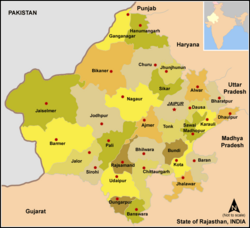
Rajputana, which literally translates to the "Land of the Rajputs," was a prominent historical region in the Indian subcontinent. This vast territory primarily encompasses the modern-day Indian state of Rajasthan, extending into parts of Gujarat, Madhya Pradesh, and southern Sindh in present-day Pakistan. The region is celebrated for its unique socio-political framework, defined by a network of Rajput kingdoms and principalities governed by a strong warrior ethos and a deep-seated tradition of kinship, honor, and martial leadership.
The identity of the region was forged by the Rajput Kshatriyas—the warrior caste—who began entering the area around the seventh century. Over time, the settlements west of the Aravalli Hills became known as Rajputana during the early Medieval Period, establishing a legacy of fortified cities and courageous governance.
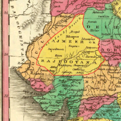
Key Facts
- Meaning: The name Rajputana means "Land of the Rajputs."
- Geography: Spans approximately 343,328 square km, divided by the Aravalli Range.
- Political Structure: Comprised of numerous princely states, including major centers like Jaipur, Jodhpur, Udaipur, Bikaner, and Jaisalmer.
- Administrative Shift: The British East India Company managed the region via the Rajputana Agency.
- Modern Transition: The region was officially renamed "Rajasthan" in the 1949 constitution.
The Evolution of the Name
The nomenclature of the region underwent several shifts over centuries. Long before the term Rajputana became standard, the area was known as Gujratra (an early form of "Gujarat"), a name derived from the Gurjara-Pratiharas. Historian R.C. Majumdar notes that the transition to "Rajputana" occurred during the early Muslim period.
The term was further formalized by the British. George Thomas is credited as the first to use the term "Rajputana Agency" in 1800. While historian John Keay suggests the name was coined by the British, it gained retrospective authenticity. For instance, in 1829, John Briggs replaced the general term "Indian princes" with "Rajpoot princes" in his translation of Ferishta's history of early Islamic India.
Geography and Landscape
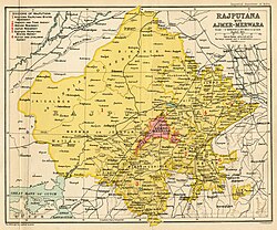
Covering an estimated 343,328 square km (132,559 square miles), Rajputana serves as the transitional hill and plateau country between the plains of North India and the main plateau of peninsular India. The region is geographically split by the Aravalli Range:
- Northwest Region: This area includes portions of the Great Indian Thar Desert. It is characterized by sandy terrain and is generally unproductive.
- Southeast Region: Located to the southeast of the range, this higher elevation area is significantly more fertile.
Administrative Structure and Transition to Rajasthan
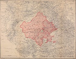
Under the British administration, the Rajputana Agency managed a complex array of dependencies, including 26 Rajput and 2 Jat princely states, along with two chiefships. The territory specifically consisted of 23 states, one Sardari, one Jagir, and the British-controlled district of Ajmer-Mewar.
The largest and most influential states included Jodhpur, Jaisalmer, Bikaner, Jaipur, and Udaipur. Following Indian independence in 1947, these fragmented states underwent a staged integration process. This political consolidation led to the creation of the modern State of Rajasthan.
While the core of Rajputana became Rajasthan, some south-eastern territories were integrated into Madhya Pradesh, and south-western areas became part of Gujarat.
Regional Summary
| Feature | Details |
|---|---|
| Total Area | ~343,328 sq km |
| Primary Geographic Divide | Aravalli Range |
| Major States | Jaipur, Jodhpur, Udaipur, Bikaner, Jaisalmer |
| Former Name | Gujratra |
| Administrative Body | Rajputana Agency (East India Company) |
| Modern Successor | Rajasthan (established 1949) |
Frequently Asked Questions
What does the word "Rajputana" mean?
Rajputana means "Land of the Rajputs," referring to the Rajput warrior clans who established numerous kingdoms in the region.
When did Rajputana become Rajasthan?
The transition occurred following the integration of princely states after 1947, and the name "Rajasthan" was officially adopted in the constitution of 1949.
What was the region called before it was known as Rajputana?
The region was previously known as Gujratra, an early form of "Gujarat" originating from the Gurjara-Pratiharas.
How did the Aravalli Range affect the geography of Rajputana?
The Aravalli Range divided the region into two distinct zones: a sandy, unproductive desert area to the northwest (including the Thar Desert) and a more fertile, higher plateau to the southeast.
Which were the largest princely states in the Rajputana Agency?
The largest states were Jodhpur, Jaisalmer, Bikaner, Jaipur, and Udaipur.