
River Wissey: A Journey Through Norfolk's Landscapes and History
The River Wissey is a significant waterway in Norfolk, serving as a tributary to the Great Ouse. Rising near East Bradenham in Shipdham, the river travels nearly 31 miles (50 km) before its eventual confluence with the Great Ouse in the parish of Fordham, south of Downham Market. Historically known as the Stoke River or River Stoke, its course has shifted over centuries; it originally flowed toward Wisbech, the town that derives its name from the river.
The river's source is located north of Shipdham, situated close to the 260-foot (79 m) contour line. Interestingly, it originates near the source of the River Yare, though the two rivers flow in opposite directions.
Key Facts
- Total Length: Approximately 31 miles (50 km).
- Source: Shipdham, near East Bradenham, Norfolk.
- Mouth: Joins the Great Ouse in Fordham.
- Historical Names: River Stoke or Stoke River.
- Navigation: Becomes navigable north of Whittington.
- Key Infrastructure: Includes the Cut-off Channel and the UK's first two-way enclosed fish pass.
The Upper Reaches: Heritage and Architecture
As the River Wissey begins its journey, it passes several sites of architectural significance. To the south lies Manor Farm, a Grade II listed 16th-century building featuring ancient fishponds. The river continues west, flowing past the Grade I listed Huntingfield Hall farmhouse and along the northern edge of Bradenham, where it separates the village center from its medieval parish church.
Moving toward Necton and Erneford Bridge, the river passes under Station Road near Erneford House, a 1700s structure built with colourwashed bricks. Further east, it reaches North Pickenham, where the parish church of St Andrew stands, having been substantially rebuilt in 1863 while retaining its original tower.
At South Pickenham, the river winds through the 139-acre (56 ha) parkland of Pickenham Hall. This estate, featuring ancient oaks and pleasure grounds, includes a hall built between 1902 and 1905 by architect Robert Weir Schultz. A rustic oak bridge from the early 1900s connects the gardens to the park.
The river then passes Great Cressingham, where a Grade I listed former manor house features 16th-century brick monograms. At Hilborough, the river is crossed by a ford at Home Lane, located near Hilborough Mill. Built in 1819, the mill still retains most of its machinery, though the paddles of its cast iron waterwheel are missing.
Military Zones and Natural Confluences
Further south, the river passes Bodney Hall farmhouse and enters a military danger area used for army training. This region was the site of RAF Bodney during the Second World War and is now part of the Stanford Training Area. Within this zone lies Langford Church, a Grade I listed medieval building; its windows are currently protected by corrugated iron sheets due to its location within the training grounds.
A key tributary joins the Wissey from the east, flowing through Stanford Water. This area saw the evacuation of Stanford village in 1942 to accommodate military needs.
Continuing west, the river passes gravel pits near Ickburgh and Bridge House, which incorporates a 13th-century leper chapel. Near Northwold, the river passes between the lakes of Didlington Hall and gravel extraction sites. Here, the River Gadder and the Oxborough Drain enter the Wissey from the north. The river becomes navigable north of Whittington, where it sits just 7 feet (2 m) above sea level.
The Lower Reaches: Engineering and Fenland Management
The head of navigation is marked by the junction with the Stringside Drain near Whittington, allowing boats up to 60 feet (18 m) to turn around. Historically, this area featured a wharf serving Whitbread maltings in the 19th century.
At Stoke Ferry, the river meets the Cut-off Channel, a 28-mile (45 km) drain constructed in the 1950s and 1960s to manage floodwaters from the River Lark, Little Ouse, and River Wissey. A guillotine sluice is used to divert floodwaters into this channel, while the main river continues via a concrete aqueduct.
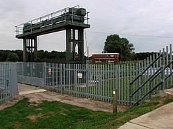
A notable environmental achievement in this section is the installation of the United Kingdom's first two-way enclosed fish pass in 2012. Funded by the Environment Agency and powered by Anglian Water, this siphon-based system allows various fish species to bypass flood defenses to reach upstream spawning grounds.
As the river approaches its end, it passes through the fenland near Hilgay. Hilgay is the largest village on the river, situated on a raised isle 66 feet (20 m) above the surrounding land—an elevation made more apparent by the shrinking of the surrounding peat during drainage. The river finally passes under the Ely to King's Lynn railway bridge before joining the Great Ouse.
Water Management Summary
| Region/Area | Managing Body (IDB) | Key Feature/Boundary |
|---|---|---|
| North of river (Stringside Drain to mouth) | Stoke Ferry IDB | Northern fenland drainage |
| South of river (Whittington to Methwold Drain) | Northwold IDB | Southern boundary: River Little Ouse |
| South of river (Methwold Drain to mouth) | Southery and District IDB | Lower southern fenland |
Frequently Asked Questions
Where does the River Wissey originate?
The river rises at Shipdham, near East Bradenham in Norfolk, close to the 260-foot (79 m) contour line.
What is the Cut-off Channel?
The Cut-off Channel is a 28-mile (45 km) drain built in the 1950s and 1960s. It diverts floodwaters from the River Lark, Little Ouse, and River Wissey toward the Denver Sluice on the River Great Ouse.
Why are the windows of Langford Church covered in iron sheets?
The windows are covered with corrugated iron sheets because the church is located within the Army's Stanford Training Area, a military danger zone.
What is unique about the fish pass at Stoke Ferry?
Installed in 2012, it was the first two-way enclosed fish pass in the United Kingdom, designed to help fish navigate flood defenses to reach spawning grounds.
How does Hilgay village differ from the surrounding land?
Hilgay sits on a raised isle approximately 66 feet (20 m) above the surrounding fenland, a height that has become more pronounced as the surrounding drained land has shrunk.