
Salar de Uyuni: The World's Largest Salt Flat
Located in the heart of southwestern Bolivia, the Salar de Uyuni is a geological marvel and the largest salt flat on Earth. Spanning approximately 10,582 square kilometres (4,086 sq mi), this vast expanse of white salt is situated in the Daniel Campos Province of the Potosí Department, perched high in the Andes Mountains at an elevation of 3,656 metres (11,995 ft).
The Salar is renowned for its extreme flatness and its ability to transform into the world's largest mirror during the rainy season. When a thin layer of water covers the surface, the landscape reflects the sky with stunning clarity across a distance of 129 km (80 miles).
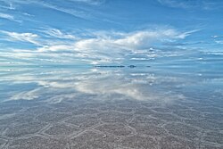
Key Facts
- Total Area: 10,582 square kilometres.
- Elevation: 3,656 metres above sea level.
- Composition: A salt crust approximately 8 metres thick covering a lithium-rich brine.
- Global Significance: Holds roughly 22% of the world's known lithium resources.
- Unique Feature: Elevation varies by less than one metre across the entire surface.
Geological Formation and Climate
The Salar de Uyuni was not always a desert. Its existence is the result of the progressive desiccation (drying out) of seven Late Pleistocene lakes. Between 30,000 and 42,000 years ago, the region was dominated by Lake Minchin. This prehistoric body of water eventually transformed into Paleo Lake Tauca, which reached depths of 140 metres (460 ft). The youngest of these prehistoric lakes, Coipasa, existed roughly 11,500 to 13,400 years ago.
As these lakes evaporated, they left behind massive evaporitic salt deposits. Today, the region consists of two major salt deserts—Salar de Coipasa and the much larger Salar de Uyuni—along with the modern lakes Poopó and Uru Uru. During the wet season, Lake Titicaca overflows into Lake Poopó, which subsequently floods the salt flats.
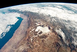
Climate Conditions
The climate is characterized by stable but extreme temperatures. Average peaks reach 21 °C (70 °F) from November to January, while lows drop to 13 °C (55 °F) in June. Nights remain cold year-round, typically ranging between −9 and 5 °C (16 and 41 °F). Humidity is low (30% to 45%), and while rainfall is sparse for most of the year, it can spike to 80 mm (3.1 in) in January.
Economic Importance and Lithium Extraction
The Salar de Uyuni is a critical component of the Lithium Triangle. The salt crust covers a pool of brine exceptionally rich in lithium, as well as sodium, potassium, magnesium, and borax. As of 2024, Bolivia holds an estimated 23 million tonnes of lithium, representing about 22% of global known resources.
Extracting this "white gold" is complex. While lithium is present in the porous halite (rock salt) body, it is most efficiently extracted by pumping the liquid brine from beneath the crust. However, the high altitude, wet climate, and presence of impurities make processing difficult. The Bolivian government currently manages these resources through joint ventures, such as with ACI Systems Alemania GmbH, to avoid total reliance on foreign corporations.
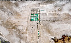
Beyond lithium, the Salar is a source of traditional salt. The Colchani cooperative manages the extraction of salt, though the annual yield (less than 25,000 t) is small compared to the estimated 10 billion tonnes of salt present in the flats.
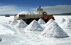
Science and Satellite Calibration
Because of its high albedo (the ability of a surface to reflect sunlight) and extreme flatness, the Salar de Uyuni is a premier site for remote sensing. It is approximately five times more effective for satellite calibration than the open ocean.
Space agencies use the Salar to calibrate radar and optical sensors. Notable missions include:
- NASA's ICESat-2: Used for GPS surveys to calibrate laser altimeters.
- Landsat-5: Used for in-flight radiometric calibration in visible and near-infrared bands.
- ESA's Sentinel-1A and Sentinel-3B: Used to calibrate radar-based measurements of surface topography.
- CryoSat-2: Utilized Interferometric synthetic-aperture radars (InSAR) to enhance altimetric precision.
Tourism and Local Attractions
The surreal landscape has made the Salar a global tourist magnet and a frequent filming location for movies such as Star Wars: The Last Jedi and The Fall.
Salt Hotels
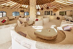
Due to the scarcity of traditional building materials, several hotels have been constructed entirely from salt blocks. The original Palacio de Sal, built in the mid-1990s, was dismantled in 2002 due to environmental pollution. A new Palacio de Sal was established around 2007 on the eastern edge of the Salar, featuring modern sanitation, a saltwater pool, and a dry sauna.
The Train Cemetery
Located 3 km outside the town of Uyuni, the train cemetery is a collection of antique locomotives. These trains were part of a rail system built by British engineers between 1888 and 1892 to transport minerals to Pacific ports. When the mining industry collapsed in the 1940s due to mineral depletion, the trains were abandoned, creating the haunting outdoor gallery seen today.
Summary of Salar de Uyuni Characteristics
| Feature | Detail |
|---|---|
| Total Area | 10,582 km² (4,086 sq mi) |
| Average Dimensions | 126 km length x 84 km width |
| Salt Crust Thickness | 8 metres |
| Elevation | 3,656 m (11,995 ft) |
| Primary Resources | Lithium, Sodium, Potassium, Magnesium |
| Max Elevation Variance | Less than 1 metre |
Frequently Asked Questions
How was the Salar de Uyuni formed?
It was formed through the evaporation of several prehistoric lakes—Lake Minchin, Paleo Lake Tauca, and Lake Coipasa—over tens of thousands of years, leaving behind thick deposits of salt.
Why is the Salar de Uyuni important for satellites?
Its extreme flatness, high reflectivity (albedo), and stable emissivity make it an ideal natural target for calibrating the radar and optical sensors of Earth observation satellites.
What is the "Lithium Triangle"?
The Lithium Triangle is a region in the Andes (including Bolivia) that contains some of the world's largest lithium reserves, primarily found in the brine beneath salt flats like the Salar de Uyuni.
Can you stay in a hotel made of salt?
Yes, there are hotels such as the Palacio de Sal where the walls, roofs, and furniture are constructed from salt blocks cut directly from the Salar.
Is the Salar de Uyuni dangerous to visit?
While generally safe, there have been reported fatal accidents caused by poorly maintained vehicles, speeding, and untrained drivers in the inhospitable terrain.