
Serbia Proper: A Historical Evolution of Central Serbia
The region known as Serbia proper—now officially referred to as Central Serbia—has served as the heartland of the Serbian people and state for centuries. From its origins as a Roman province to its role in the modern Balkan landscape, this territory has been shaped by shifting empires, revolutionary uprisings, and evolving political boundaries.
Ancient and Medieval Foundations
During the Roman era, the region was part of Moesia. The province of Moesia Superior was governed from its capital, Viminacium, located in present-day Kostolac. By the 6th and 7th centuries, the Balkans were overwhelmed by the Slavs (Sclaveni). Among them, the Serbs established themselves in what is now southwest Serbia during the Early Middle Ages. By the 9th century, the Royal Frankish Annals also noted the presence of the Braničevci and Timočani in the eastern regions.
The core of the medieval Serbian state was centered in Raška, in the southwest, with Stari Ras serving as the capital of the Grand Principality of Serbia. As the state expanded eastward, the "Serbian lands" grew to encompass most of Serbia proper, along with parts of northern Montenegro, Kosovo, northern Macedonia, and eastern Bosnia and Herzegovina. Notable leadership included King Stefan Dragutin of Syrmia (r. 1282–1316), who maintained capitals in both Debrc and Belgrade.
Following the collapse of the Serbian Empire, the region of "Moravian Serbia" emerged under the rule of Lazar (r. 1373–89) and Stefan Lazarević (r. 1389–1402), with Kruševac as its capital. This era transitioned into the Serbian Despotate, centered in Belgrade, before the Ottoman conquests of the 15th century. The Ottomans subsequently established the Sanjak of Smederevo, which was initially based in Smederevo and later moved to Belgrade after 1521, becoming known as the "Pashaluk of Belgrade."
The Struggle for Independence
The 18th century saw brief shifts in power. Between 1718 and 1739, the Habsburg monarchy occupied the Sanjak of Smederevo, administering it as the Kingdom of Serbia. Despite the efforts of the Serbian Militia during the 1737–1739 war, the region returned to Ottoman control. A similar brief occupation occurred in the northern half of Serbia proper between 1787 and 1791.
The path to sovereignty began with the First Serbian Uprising (1804–13), creating a de facto state known as "Revolutionary Serbia." Although the Ottomans retook the area in 1813, the Second Serbian Uprising (1815–17) resulted in Serbia being recognized as an autonomous principality. Full independence was finally achieved in 1878, which also saw the territory expand to the southeast.
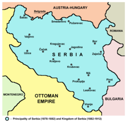
20th Century Transitions and Modern Status
Serbia continued to expand during the Balkan Wars (1912–13), gaining control of much of present-day North Macedonia and Kosovo. Following World War I in 1918, further gains were made in the Sandžak region and the north (Vojvodina). On December 1, 1918, Serbia became part of the Kingdom of Serbs, Croats and Slovenes. In 1929, the region was divided among five banovine (provinces), including the Morava Banovina based in Niš.
The period between 1941 and 1944 was marked by Axis occupation during World War II. Most of the territory was under a German Wehrmacht military administration with a puppet government. Other areas were partitioned: Italy occupied the southwestern Sandžak region, Bulgaria annexed southeastern parts, and southern Kosovo was annexed to the Kingdom of Albania.
After liberation by the Yugoslav Partisans in 1944, Serbia became a republic within socialist Yugoslavia. In 1945, the creation of autonomous provinces in Vojvodina and Kosovo led to the remaining area being called uža Srbija ("Serbia proper"). By the early 1990s, the government replaced this term with Centralna Srbija ("Central Serbia").
Today, Central Serbia is organized into three statistical regions: Belgrade, Šumadija and Western Serbia, and Southern and Eastern Serbia.
Key Facts
- Roman Era: The region was part of Moesia, with Viminacium as the capital of Moesia Superior.
- Medieval Core: Raška served as the heart of the early Serbian state.
- Independence: Serbia achieved full independence from the Ottoman Empire in 1878.
- Terminology: The term uža Srbija was officially replaced by "Central Serbia" in the 1990s.
- Modern Structure: Central Serbia currently comprises three statistical regions.
| Period/Era | Administrative Name | Key Capital/Center |
|---|---|---|
| Roman Period | Moesia Superior | Viminacium |
| Early Middle Ages | Grand Principality of Serbia | Stari Ras |
| Late 14th Century | Moravian Serbia | Kruševac |
| 15th-16th Century | Serbian Despotate / Sanjak of Smederevo | Belgrade |
| 1878-1918 | Independent State of Serbia | Belgrade |
| Post-1945 | Central Serbia (uža Srbija) | Belgrade |
Frequently Asked Questions
What is the difference between Serbia proper and Central Serbia?
They refer to the same geographic area. "Serbia proper" (or uža Srbija) was the term used to distinguish the core region from the autonomous provinces of Vojvodina and Kosovo. In the 1990s, the Serbian government officially adopted the term "Central Serbia."
Which city served as the capital of Moesia Superior?
Viminacium, located in present-day Kostolac, was the capital of the Roman province of Moesia Superior.
When did Serbia become a fully independent state?
Serbia became a fully independent state in 1878, following the Congress of Berlin, which also expanded its territory to the southeast.
What was the Sanjak of Smederevo?
The Sanjak of Smederevo was an Ottoman administrative division established after the conquest of the Serbian Despotate. It was initially based in Smederevo and later moved to Belgrade in 1521, where it became known as the Pashaluk of Belgrade.
How was the region divided during World War II?
Most of the territory was under German Wehrmacht occupation with a puppet government. However, the Sandžak region was occupied by Italy, southeastern parts were annexed by Bulgaria, and southern Kosovo was annexed to the Kingdom of Albania.