
Sudan Geography and Environmental Profile
Sudan is a prominent nation located in the intersection of North and East Africa. Positioned within both the Northern and Eastern Hemispheres, it serves as a bridge between the African continent and the Greater Middle East. Its vast landscape is characterized by diverse terrains, ranging from the arid expanses of the Sahara Desert—the world's largest hot desert—to the strategic shores of the Red Sea.
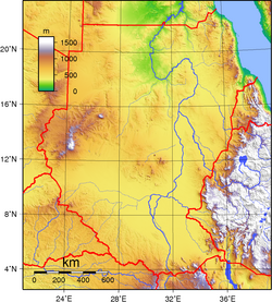
Key Facts
- Total Area: 1,886,068 km²
- Highest Point: Kinyeti (3,187 m / 10,456 ft)
- Lowest Point: Red Sea (0 m)
- Coastline: 853 km along the Red Sea
- Time Zone: East Africa Time (UTC+03)
- Population: 30,894,000 (as of 2008)
Physical Geography and Borders
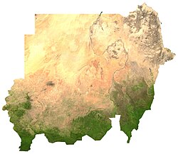
Sudan possesses an extensive network of land boundaries totaling 6,751 km. The country shares borders with seven different nations, creating a complex geopolitical landscape in the heart of Africa.
Land Boundaries by Country
- South Sudan: 1,937 km
- Chad: 1,360 km
- Egypt: 1,273 km
- Ethiopia: 769 km
- Eritrea: 605 km
- Libya: 383 km
- Central African Republic: 175 km
Environmental and Natural Features
The environment of Sudan is defined by its varied ecoregions, which support a wide array of fauna, including diverse bird and mammal species. While the country features mountains and volcanoes, it contains no glaciers due to its predominantly warm and arid climate.
The nation's hydrology is dominated by its river systems and its access to the Red Sea, which provides critical maritime access. Additionally, Sudan is home to several recognized World Heritage Sites, highlighting its historical and natural significance.
| Feature | Detail |
|---|---|
| Hemispheres | Northern and Eastern |
| Total Land Boundaries | 6,751 km |
| Coastline Length | 853 km |
| Highest Elevation | 3,187 m (Kinyeti) |
| Global Population Rank | 32nd (2008) |
Administrative Divisions
Sudan is organized into a structured system of governance consisting of states and districts. The country is divided into several states, which are further subdivided into 133 districts to manage local administration.
The States of Sudan
The administrative landscape includes the following states:
- Blue Nile, Al Jazirah, and Kassala
- Khartoum, Northern, and River Nile
- Red Sea, Al Qadarif, and Sennar
- White Nile, North Darfur, South Darfur, and West Darfur
- North Kordofan and South Kordofan
Frequently Asked Questions
What is the highest point in Sudan?
The highest point in Sudan is Kinyeti, which reaches an elevation of 3,187 meters (10,456 feet).
Which country shares the longest border with Sudan?
South Sudan shares the longest land boundary with Sudan, measuring 1,937 km.
Does Sudan have any glaciers?
No, there are no glaciers located within Sudan.
How is Sudan administratively divided?
Sudan is divided into states, which are further subdivided into 133 districts.
What is the total area of Sudan?
The total area of Sudan is 1,886,068 km².