
Water Body Stratification
Water stratification is the natural separation of a water body into horizontal layers based on density. In a stable state, denser water settles at the bottom while lighter water remains on top. This phenomenon occurs across various aquatic environments, from the vast depths of the open ocean to small landlocked pools, and it plays a critical role in how heat, nutrients, and gases are distributed throughout the planet's hydrosphere.
The boundary where the most rapid change in density occurs is known as the pycnocline. Depending on what drives the density difference—temperature or salinity—this layer may be specifically referred to as a thermocline or a halocline.
Key Facts
- Density Drivers: Stratification is primarily caused by variations in temperature (thermal) and salinity (haline).
- Climate Impact: Upper ocean stratification increased by 0.7% to 1.2% per decade between 1960 and 2018.
- Freshwater Density: Pure freshwater reaches its maximum density at 4°C, which drives seasonal mixing in temperate lakes.
- Barriers to Mixing: Stratified layers act as physical barriers that inhibit the exchange of oxygen, carbon, and nutrients.
- Global Trends: The southern oceans (south of 30°S) have seen the strongest rate of stratification since 1960.
Ocean Stratification
In the ocean, stratification is generally stable because the sun heats the surface, making the top layer less dense than the cold depths. While mechanical mixing from wind can reduce this separation, convection—where warm water rises and cold water sinks—often reinforces it. The uppermost layer, known as the surface mixed layer, is kept uniform by these wind and thermal effects.
Certain coastal processes can break through these layers. Upwelling occurs when wind moves surface water away from land, allowing cold, nutrient-rich deep water to rise. Conversely, downwelling occurs when water moves toward land and sinks, transporting surface water to the depths.
Recent data indicates that climate change is increasing upper ocean stratification, primarily through rising temperatures. This strengthens the mixing barriers, particularly in the southern oceans, followed by the Pacific, Atlantic, and Indian Oceans.
![The halo-, thermo-, and pycnocline at 10E, 30S. For this image the annual means of the year 2000 from the GODAS Data[6] has been used.](/images/37/73/377392b980fb7c3a70965a6a5c4bca1c1281b3475fabd7485b8249bd4a5ab5fb.png)
Estuarine Dynamics
An estuary is a partially enclosed coastal body of brackish water (a mix of fresh and salt water) where rivers flow into the open sea. Because freshwater is less dense than saltwater, and warmer water is less dense than colder water (above 4°C), estuaries often exhibit complex vertical layering.
Vertical mixing in estuaries is driven by wind forces at the surface, turbulence at the ocean-estuary interface at the bottom, and internal currents caused by tides and river inflow. This mixing determines the type of estuarine circulation:
- Salt Wedge Estuaries: Dominated by river flow with minimal tidal influence. Freshwater floats on top, while denser seawater pushes landward along the bottom in a wedge shape. The Mississippi estuary is a prime example.
- Partially Stratified Estuaries: Occur when tidal forcing is stronger, creating turbulent eddies that mix the water column. This results in a gradual increase in salinity from surface to bottom, as seen in the Thames.
- Vertically Homogeneous Estuaries: High tidal flow relative to river discharge creates intense mixing, eliminating the vertical salinity gradient entirely.
- Fjords: Highly stratified basins with sills. Freshwater inflow exceeds evaporation, and deep seawater may remain stagnant until a storm flushes the system.
- Inverse Estuaries: Found in dry climates where evaporation exceeds freshwater inflow. A high-salinity "plug" forms, inhibiting the mixing of estuarine and oceanic waters.
Lake Stratification
Lake stratification is typically thermal. In warm weather or when frozen, lakes separate into three distinct layers: the epilimnion (warm surface layer), the thermocline or metalimnion (middle transition layer), and the hypolimnion (cold bottom layer).
Because freshwater is densest at 4°C, temperate lakes undergo a cyclical "overturn." As surface waters reach 4°C in spring and fall, they sink, mixing the entire water column. Lakes that turn over twice a year are called dimictic, while those that remain stratified for extended periods are meromictic. Shallow lakes that mix regularly due to wind or cooling are termed polymictic.
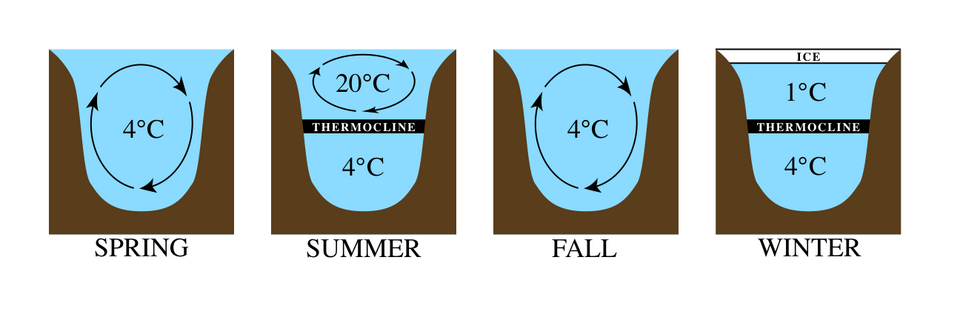
Winter regimes also vary. Cryostratified lakes maintain inverse stratification near the ice surface with average temperatures near 4°C, whereas cryomictic lakes lack an under-ice thermocline and average closer to 0°C.
Anchialine Systems
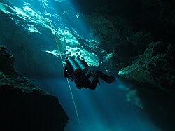
Anchialine systems are landlocked bodies of water—either pools or caves—that maintain a subterranean connection to the ocean. These are common in coastal aquifers with limestone or volcanic lava bedrock, such as in Hawaii, the Yucatán Peninsula, and the Canary Islands.
These systems are density-stratified, with fresh or brackish water at the surface and saline ocean water intruding at depth. In karst caves, the boundary between these layers, called the halocline, is often visible to the naked eye due to the different refractive indices of fresh and salt water.
Summary of Water Body Types
| Water Body | Primary Driver | Key Feature | Example/Type |
|---|---|---|---|
| Ocean | Temperature & Salinity | Pycnocline / Surface Mixed Layer | Southern Ocean |
| Estuary | Salinity Gradient | Salt Wedge / Homogeneous | Mississippi / Thames |
| Lake | Temperature | Epilimnion, Thermocline, Hypolimnion | Dimictic / Meromictic |
| Anchialine | Salinity | Subterranean ocean connection | Karst caves / Volcanic pools |
Frequently Asked Questions
What is the difference between a pycnocline, thermocline, and halocline?
A pycnocline is a general term for a layer where density changes rapidly. A thermocline is a pycnocline specifically caused by a rapid change in temperature, while a halocline is caused by a rapid change in salinity.
Why does freshwater reach maximum density at 4°C?
This is a unique physical property of water. As freshwater cools toward 4°C, it becomes denser and sinks; however, once it cools below 4°C, it begins to become less dense again, which is why ice floats on top of liquid water.
How does climate change affect ocean stratification?
Climate change increases the temperature of the surface waters, making them significantly less dense than the deep water. This increases the density difference between layers, strengthening the stratification and creating larger barriers to the mixing of nutrients and gases.
What is a salt wedge estuary?
A salt wedge estuary occurs when a strong river flow pushes freshwater over the top of denser seawater. The seawater moves landward along the bottom in a wedge shape, with a sharp density interface separating the two layers.
What distinguishes an anchialine pool from an anchialine cave?
The primary difference is light availability. Pools are euphotic (receive sunlight), whereas caves are aphotic (dark), which significantly influences the biological communities that can survive in each system.