
Wernigerode: Geography and Climate of the Harz Gateway
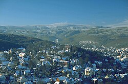
Nestled on the northeastern flank of the Harz Mountains in central Germany, Wernigerode serves as a picturesque gateway to one of the region's most iconic landscapes. Situated at approximately 250 metres (820 ft) above sea level, the town is positioned at the foot of the Brocken, the highest peak in the Harz range. Its strategic location is supported by the B 6 and B 244 federal highways and a railway line connecting Halberstadt to Vienenburg, which further links the major cities of Halle (Saale) and Hanover.
The town is also a notable stop on the Orange Route, a popular German-Dutch holiday road.
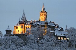
Geographic Landscape and Waterways
The physical layout of Wernigerode is defined by its relationship with the surrounding mountains and water systems. The River Holtemme flows through the town, joined near the western gate by the Zillierbach stream (known as the Flutrenne near its mouth). To the north, the Barrenbach flows through various ponds before emptying into the Holtemme in the village of Minsleben.
The borough spans 9.5 kilometres (5.9 mi) from west to east and 6 kilometres (3.7 mi) from north to south. The elevation varies significantly across this area, ranging from a low of 215 metres (705 ft) to the summit of the Brocken at 1,141 metres (3,743 ft).
A defining geological feature is the Northern Harz Boundary Fault. This fault line crosses the borough, creating the town's castle hill to the southeast and passing through the suburb of Hasserode to the west-southwest. Crucially, this fault serves as the watershed between two major river systems: precipitation to the north flows into the Weser, while water to the southeast and northeast flows into the Elbe.
Town Divisions and Administration
Wernigerode is structured into several distinct areas. The historic town centre is divided into the Altstadt (old town) and the Neustadt (new town). The broader borough includes several residential estates—Stadtfeld, Burgbreite, and Harzblick—as well as the villages of Hasserode and Nöschenrode, which were incorporated before 1994.
Additionally, five villages with their own local councils were integrated after 1994: Benzingerode, Minsleben, Reddeber, Schierke, and Silstedt.
Climate and Weather Patterns
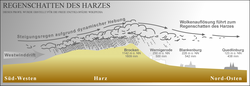
Wernigerode is located within the Central European transition subzone of the temperate climatic zone. The local weather is heavily influenced by orographic rainfall—precipitation produced when moist air is lifted as it moves over a mountain range. Because Wernigerode sits on the leeward side of the Harz Mountains, it exists in a rain shadow, meaning it receives less precipitation than similar temperate regions that lack such mountain protection.
The town also experiences occasional föhn winds, which are warm, dry winds that descend the slopes and lead to an increase in local temperatures.
On average, the annual temperature is 9.5 °C (49.1 °F) with annual precipitation of 500 millimetres (20 in). Summers (June to August) are the warmest months, while winters (December to February) are the coldest. July typically sees the highest rainfall, while February is the driest month.
| Metric | Winter (Dec-Feb) | Spring (Mar-May) | Summer (Jun-Aug) | Autumn (Sep-Nov) | Annual Average |
|---|---|---|---|---|---|
| Mean Daily Max Temp (°C) | 4.5 to 5.3 | 8.9 to 18.2 | 21.6 to 24.2 | 8.6 to 19.2 | 14.2 |
| Daily Mean Temp (°C) | 1.6 to 2.7 | 4.8 to 13.2 | 16.5 to 19.0 | 5.8 to 14.5 | 9.9 |
| Mean Daily Min Temp (°C) | -2.0 to -0.5 | 0.6 to 7.5 | 11.0 to 13.2 | 2.4 to 9.4 | 5.4 |
| Avg Precipitation (mm) | 35.9 to 52.3 | 32.0 to 64.2 | 47.0 to 67.1 | 41.3 to 55.1 | 613.9 |
Key Facts
- Highest Point: The Brocken at 1,141 metres (3,743 ft).
- Watershed: The Northern Harz Boundary Fault divides water flow between the Weser and Elbe rivers.
- Climate Effect: The town is located in a rain shadow, reducing overall precipitation.
- Average Temperature: Annual mean of 9.5 °C (49.1 °F).
- Infrastructure: Located on the Orange Route and connected via the B 6 and B 244 highways.
- Snow Load: Classified as snow load class 3 per DIN 1055 standards.
Frequently Asked Questions
What is the rain shadow effect in Wernigerode?
The rain shadow occurs because the Harz Mountains block much of the incoming moisture. As air descends the leeward side where Wernigerode is located, it becomes drier, resulting in less precipitation than in other temperate regions.
Which rivers are associated with the town?
The River Holtemme is the primary river flowing through the town. It is joined by the Zillierbach stream and receives water from the Barrenbach via the village of Minsleben.
How does the Northern Harz Boundary Fault affect the area?
The fault line creates the physical elevation for the town's castle hill and acts as a geographical divide; precipitation falling north of the fault flows toward the Weser, while water to the southeast and northeast flows toward the Elbe.
What are the typical temperature ranges in Wernigerode?
Daily mean temperatures range from a low of approximately 1.6 °C in February to a high of 19.0 °C in July, with an overall annual average of 9.9 °C.
Which villages are part of the Wernigerode borough?
The borough includes Hasserode, Nöschenrode, Benzingerode, Minsleben, Reddeber, Schierke, and Silstedt.