
White Ladies Aston: A Comprehensive History from Iron Age Saltways to the Railway Era
The village of White Ladies Aston in Worcestershire possesses a rich tapestry of history, stretching from ancient trade routes to the strategic maneuvers of the English Civil War. Its evolution from a collection of Saxon farms to a structured parish reflects the broader shifts in English land ownership, law, and industry over two millennia.
Ancient Origins and Saxon Foundations
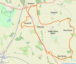
Long before the formal establishment of the village, the landscape was defined by saltways—ancient trade routes used during the Iron Age to transport salt from Droitwich to Oxford. Two such routes, the A44 (Evesham Road) and Edward's Lane, served as early markers for the parish boundaries.
During the Anglo-Saxon period, the settlement was known as "Eastun," "Estun," or "Aston," meaning "East Farm" in relation to the Cathedral of Worcester. The area was also home to a mound named after Oslaf, a Bernician prince. By 964 A.D., this site became the meeting place for the Oswaldslow Hundred Court and was renamed after Oswald; it is known today as Low Hill.
The parish boundaries were formalized through a series of royal grants and legal rulings between 974 and 984 A.D. King Edgar established the eastern boundary at the Bow Brook in 974 A.D. In 976, the Hundred Court expanded the parish westward to include Snaetch's Hill (now Sneachill) following a land dispute. By 984, Bishop Oswald had defined the southern and southwestern borders, tracing a path from Snaet's Spring through the Rommes Valley to the Bow Brook.
The Norman Era and the Domesday Book
By the time of the Domesday Survey in 1086, the land was divided among major owners, with the Church of St. Mary's, Worcester, holding the rights to Oswaldslow under Tenant-in-chief Wulfstan, Bishop of Worcester. The settlement was split into two distinct sections:
- Aston Episcopi: The northern section, part of the Manor of Northwick, held by Ordric. It consisted of 3 hides and 1 virgate, valued at 40s.
- Nether Aston: The southern section, part of the Manor of Warndon, held by Urse D'Abitot and leased to Robert de Bracy. This area included woodland and meadow, valued at 16s.
The Founding of St John the Baptist Church
In 1204, Robert de Everay gifted two palfreys (riding horses) to the Bishop of Worcester. In exchange, he gained the right to appoint the vicar for Aston Episcopi and sought to build a stone church. This resulted in the construction of St John the Baptist church, which remains a landmark of the village today.
Forest Law and the Evolution of the Manors
In the early 13th century, the village was subject to strict Forest Laws, which regulated hunting and wood gathering in the Horewell Forest. However, the Charter of King Henry III in 1217 removed these laws from Aston parish due to widespread deforestation driven by the need for more farmland. This distinguished Aston from the neighboring village of Churchill, which remained under the restrictive laws of the Forest of Feckenham.
The Origin of "White Ladies"
The unique name of the village stems from the 13th century. In 1255, a portion of the revenue from Aston Episcopi was granted to eight Cistercian nuns at the newly formed Whistones Priory in Barbourne. Because the Cistercian Order wore white habits, the area became known as White Ladies Aston.
The manor's ownership shifted significantly during the Reformation. Whistones Nunnery was dissolved in 1536 by Henry VIII. After passing through several owners, including Thomas Hill, the manor was sold in 1612 to Robert Berkeley of Spetchley, whose family continues to own the lands today.
The Manor of Aston Bruley
Parallel to Aston Episcopi was the Manor of Aston Bruley (formerly Nether Aston). Held by the Bruley family in the 12th century, it later passed to the Danvers and Hubaud families before being sold to William Solley in 1558. By the time of the English Civil War, the property was owned by the Symonds family, who were staunch Roundheads (Parliamentary supporters).
Conflict and Turmoil: The English Civil War
White Ladies Aston played a strategic role during the English Civil War. In 1643, local figures John Good and Charles Berkeley joined Prince Rupert's Royal Cavalry to support King Charles I at the Battle of Newbury.
The village's Aston Hall Farm became a site of historical significance in 1651. On August 30, Oliver Cromwell, General of the Parliamentary Forces, spent the night there with Mr. Justice Symonds. Meanwhile, at Aston Court, Parliamentary troops plundered the farm after the Royalist Good family refused to provide billets (lodgings).
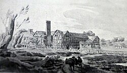
Following his stay, Cromwell moved to Spetchley on August 31. On September 3, 1651, the Battle of Worcester commenced. Cromwell's forces routed the Royalists, forcing Charles II to flee the city and eventually the country, remaining in exile until the Restoration of 1660.
Crime, Charity, and the Industrial Shift
The 18th century saw a dark chapter in 1707 when Thomas Symond of Aston Hall Farm and John Palmer led a gang that murdered Mrs. Palmer and her maid in Upton Snodsbury. Following their execution at Red Hill in Worcester, their leased lands reverted to Worcester Cathedral. Bishop Lloyd used these revenues to establish Bishop Lloyd's Charity, funding two schools in Trinity Hall, Worcester.
The Agricultural Revolution
Until 1825, the village utilized an open field system characterized by medieval ridge and furrow patterns. This changed with the White Ladies Aston Inclosure Act 1825, which legally mandated the enclosing of land into rectangular fields bounded by hedges and fences, a layout still visible in the landscape today.
The Railway Era
The arrival of the Birmingham and Gloucester Railway brought Spetchley station to the northwestern edge of the village on June 24, 1840. Opened by I.K. Brunel, the station served as the primary gateway to Worcester for many years. While it closed to passengers in 1855 and finally as a goods yard in 1963 following the Beeching Report, the area's rail connectivity was renewed on February 23, 2020, with the opening of the Worcestershire Parkway station at Stoulton.
Key Facts
- Ancient Trade: The village was shaped by Iron Age saltways linking Droitwich to Oxford.
- Naming: "White Ladies" refers to the white habits of the Cistercian nuns of Whistones Priory.
- Civil War: Oliver Cromwell stayed at Aston Hall Farm on the eve of the Battle of Worcester in 1651.
- Land Reform: The 1825 Inclosure Act replaced medieval open fields with the rectangular hedged fields seen today.
- Rail History: Spetchley station was opened by I.K. Brunel in 1840.
| Manor | Domesday Status (1086) | Key Historical Association | Later Ownership/Fate |
|---|---|---|---|
| Aston Episcopi | Held by Ordric (3 hides, 1 virgate) | Whistones Priory (Cistercian Nuns) | Berkeley of Spetchley / See of Worcester |
| Nether Aston (Aston Bruley) | Held by Urse D'Abitot / Robert de Bracy | Aston Hall Farm (Cromwell's stay) | Symonds Family (Parliamentarians) |
Frequently Asked Questions
Why is the village called White Ladies Aston?
The name originates from the 13th century when revenue from the manor was granted to Cistercian nuns from Whistones Priory. These nuns wore white habits, leading to the designation "White Ladies."
What was the significance of the saltways?
The saltways were ancient Iron Age trade routes used to transport salt from Droitwich. In White Ladies Aston, the A44 and Edward's Lane follow these routes and helped define the original parish boundaries.
How did Oliver Cromwell connect to the village?
Oliver Cromwell spent the night of August 30, 1651, at Aston Hall Farm with Mr. Justice Symonds just before the Battle of Worcester, which took place on September 3, 1651.
What changed during the Inclosure Act of 1825?
The Act ended the medieval open field system of ridge and furrow farming, legally enforcing the division of land into the rectangular, hedged fields that characterize the local countryside today.
What happened to Spetchley station?
Opened by I.K. Brunel in 1840, it served as a main entry point for Worcester. It closed to passengers in 1855 and completely closed as a goods yard in 1963 following the Beeching Report.