
Wood End Light: A Historic Sentinel of Provincetown
Perched at the southwest end of Long Point in Provincetown, Massachusetts, Wood End Light serves as a vital navigational aid for vessels approaching Provincetown Harbor. Situated near the southernmost extent of the Provincetown Spit, this historic beacon has guided mariners through the challenging coastal waters of Cape Cod for over a century.
The site's history began in 1864 with the establishment of a lookout station. By 1872, the permanent lighthouse tower was completed, marking the beginning of its official service as a light station.
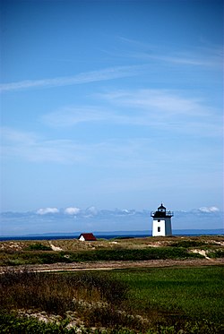
Key Facts
- Location: Wood End, Long Point, Provincetown, MA.
- Established: First lit on November 20, 1872.
- Design: A 39-foot square, pyramidal brick tower on a concrete foundation.
- Innovation: First Massachusetts lighthouse to utilize solar energy (1981).
- Heritage: Listed on the National Register of Historic Places since June 15, 1987.
Architectural Design and Evolution
The Wood End Light tower is characterized by its square, pyramidal shape, constructed from brick and supported by a concrete foundation. While it is currently painted white with a black lantern, the structure was originally painted brown. The tower stands 39 feet tall, with a focal height—the distance from the light source to the mean sea level—of 45 feet.
The design of Wood End Light is identical to the Long Point Light Station, which was completed three years later in 1875 further down the peninsula.
Supporting Structures
In 1896, the station was expanded to include a wooden keeper's house, a storage shed, and an oil house to support the personnel maintaining the light. However, as maritime technology evolved and the need for on-site staffing vanished, the station was automated in 1961. Following automation, the keeper's house and storage shed were razed, leaving only the tower and the original oil house standing today.
Technical Specifications and Navigation
The lighthouse originally utilized a fifth-order Fresnel lens—a specialized lens designed to concentrate light into a powerful beam. This has since been replaced by a VRB-25 optic. The current light characteristic is a red flash every 10 seconds (Fl Red 10s), visible for a range of 13 nautical miles (approximately 24 kilometers).
To assist vessels during low visibility, the station employs a fog signal. The current system emits one 3-second blast every 30 seconds, replacing the 1,000 lb (450 kg) fog bell that was in use starting in 1902.
| Feature | Detail |
|---|---|
| Coordinates | 42°1′16.4″N 70°11′36.6″W |
| Tower Height | 39 feet (12 m) |
| Focal Height | 45 feet (14 m) |
| Light Range | 13 nautical miles (24 km) |
| NRHP Reference No. | 87001504 |
Frequently Asked Questions
When was Wood End Light first lit?
The lighthouse was first illuminated on November 20, 1872.
What makes Wood End Light technologically significant in Massachusetts?
In 1981, Wood End Light became the first lighthouse in Massachusetts to be converted to solar energy to power its light and fog signal equipment.
Is Wood End Light protected as a historic site?
Yes, it was added to the National Register of Historic Places on June 15, 1987, as part of the Lighthouses of Massachusetts TR multiple property submission.
What happened to the lighthouse keeper's residence?
The wooden keeper's house, along with a storage shed, was demolished in 1961 after the station was automated, as manned staffing was no longer required.
How does the current light signal appear to sailors?
The light exhibits a red flash every 10 seconds, which can be seen from up to 13 nautical miles away.