
Yorkshire Topography and Geology
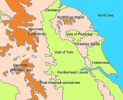
The landscape of Yorkshire is a complex mosaic of geological eras, shaped by ancient seas, tectonic uplifts, and the powerful forces of the last ice age. From the rugged peaks of the Pennines to the flat plains of Holderness, the region's topography is a direct reflection of the rocks beneath the surface and the glacial processes that carved the land.
The Pennines
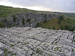
The Pennines form an anticline (an arch-like fold in rock strata) extending north to south. This range is primarily composed of Millstone Grit and underlying Carboniferous Limestone. In the North Pennines AONB, limestone is exposed at the surface, while in the Yorkshire Dales, this geology has created extensive cave systems and watercourses known as "gills" and "pots".
These potholes are particularly common on the eastern side and include some of England's deepest chasms, such as Gaping Gill (over 350 ft / 107 m) and Rowten Pot (365 ft / 111 m). The region is also famous for its limestone pavements—flat, weathered rock surfaces. Between Skipton and the Peak, a narrow belt of gritstone consists of shales and sandstones, creating high, uncultivable moors and peat-mosses.
The Yorkshire Coalfield and Magnesian Limestone
The Yorkshire Coalfield is underlain by Coal Measures, consisting mainly of mudstone with sandstone beds and coal seams. Because sandstone resists erosion more effectively than mudstone, the landscape is characterized by recurring escarpments. Broad, glaciated valleys floored with fertile alluvial deposits cut through this area.
To the east of the Pennines lies the Magnesian Limestone belt, a narrow strip of undulating land overlooking the Vale of York. These deposits formed in an evaporating inland sea during the Permian period. The geology consists of a lower layer of dolomite and dolomitic limestone, overlain by red mudstone with gypsum. This composition leads to numerous swallow holes caused by the underground dissolution of the minerals.
This sequence is visible in the Nidd gorge at Knaresborough, the Wharfe valley at Wetherby, and the Don gorge near Doncaster. While glacial moraines (accumulations of debris) mask the limestone in the Bedale area, the soils south of Wetherby remain highly fertile due to the limestone and clay deposits.
The Vales of Mowbray and York
The surface of the Vale of York is dominated by drift deposits—materials transported and deposited by glaciers. While Triassic sandstone, mudstone, and lower Jurassic mudstone lie beneath, they are completely hidden by glacial till, sand, and gravel.
Two prominent features are the Escrick and York moraines, which form curving ridges across the vale. North of these ridges, the land consists of clay, sand, and gravel left by a prehistoric glacial lake, alongside river alluvium deposited by local streams.
The North York Moors
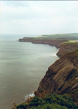
The North York Moors are dominated by Jurassic rocks laid down in tropical seas between 205 and 142 million years ago. These strata, ranging from shales to coral-derived limestones, are well-exposed along the coast from Staithes to Filey.
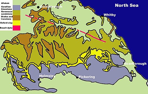
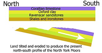
Approximately 30 million years ago, tectonic movements uplifted and tilted the land southward. This tilt exposed the oldest rocks (shales and ironstones) in the north, while the middle layers formed the high moorland sandstones and the youngest layers created tabular limestone hills. Rosedale provides a clear example where rivers have cut through to expose older strata.
During the Quaternary period, the area underwent several glaciations, ending with the Devensian about 10,000 years ago. While the highest moors remained ice-free, meltwater was trapped by ice to the north, west, and east, forcing huge torrents southward. This process gouged out the Newtondale valley and created a vast lake in the Vale of Pickering, which eventually overflowed to carve the steep Kirkham gorge.
The Vale of Pickering and Yorkshire Wolds
The Vale of Pickering, the site of the post-glacial Lake Pickering, is predominantly level and covered in glacial drift. Underlying Jurassic sandstones have little impact on the surface, though some Jurassic limestone outliers exist near the Howardian Hills.
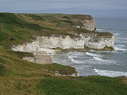
In contrast, the Yorkshire Wolds are formed from Cretaceous chalk, arching from the Humber estuary to the North Sea coast. This geology creates dramatic cliffs at Flamborough Head, Bempton Cliffs, and Filey. The Wolds are an elevated, rolling plateau with deep, flat-bottomed glacial valleys. Because chalk drains water exceptionally well, surface water is scarce and many valleys are dry.
Holderness and the Humberhead Levels
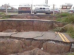
Holderness is underlain by Cretaceous Chalk, but it is buried deep beneath Devensian glacial deposits of till and boulder clay. This creates a flat, rural lowland plain featuring "meres" (peat-filled depressions), drumlin mounds, and kettle holes. The fertile soils support intensive farming, but the coast is plagued by rapid marine erosion.
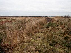
The Humberhead Levels were shaped by Glacial Lake Humber, which was impounded by an ice front at the Humber Gap. The lake filled with clay sediments up to 20 meters thick, which are now overlain by peat deposits forming raised mires. At the base of these peat layers, remains of a buried forest can be found.
Key Facts
- Deepest Potholes: Rowten Pot (365 ft) and Gaping Gill (350 ft) are among England's largest.
- Geological Eras: The region features rocks from the Permian, Triassic, Jurassic, and Cretaceous periods.
- Wolds Drainage: The Cretaceous chalk of the Wolds provides excellent drainage, resulting in few surface water sources.
- Coastal Erosion: Holderness is characterized by a flat landscape and rapid marine erosion.
- Glacial Impact: The Devensian glaciation ended roughly 10,000 years ago, leaving behind boulder clay and moraines.
| Region | Primary Rock/Deposit | Key Topographic Feature |
|---|---|---|
| Pennines | Carboniferous Limestone / Millstone Grit | High moorlands, pots, and gills |
| Magnesian Limestone Belt | Dolomite / Gypsum | Undulating land with swallow holes |
| North York Moors | Jurassic Sandstone / Shale / Limestone | Tilted plateau and deep dales |
| Yorkshire Wolds | Cretaceous Chalk | Rolling plateau and dry valleys |
| Holderness | Glacial Till / Boulder Clay | Flat lowland plain |
| Humberhead Levels | Lake Clay / Peat | Raised mires and buried forests |
Frequently Asked Questions
What are "pots" and "gills" in the Pennines?
Pots are deep potholes or vertical cave shafts, while gills are steep-sided watercourses, both formed by the erosion of Carboniferous Limestone.
How was the Newtondale valley formed?
It was gouged out by huge torrents of meltwater from the Esk valley area that were forced southwards because they were blocked by ice to the north, west, and east.
Why are the valleys in the Yorkshire Wolds often dry?
The Cretaceous chalk that forms the Wolds is highly permeable, providing exceptionally good drainage that prevents surface water from accumulating.
What is the significance of the Devensian glaciation in Holderness?
The Devensian glaciation deposited the till, boulder clays, and glacial lake clays that now form the flat, fertile lowland plain of Holderness.
What caused the tilt of the North York Moors?
About 30 million years ago, earth movements uplifted the land and tilted it towards the south, exposing older rocks in the north and younger rocks in the south.