
Alto Cenepa Incident: The Final Border Conflict Between Ecuador and Peru
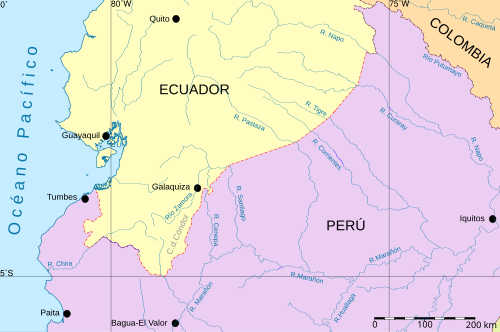
The Alto Cenepa War, also known as the Cenepa War or the Third Ecuadorian-Peruvian War, was a brief but intense military confrontation that took place from January 26 to February 28, 1995. Fought in the rugged terrain of the Cenepa valley, this localized conflict represented the climax of one of the longest-running territorial disputes in the Western Hemisphere.
The fighting centered on the eastern side of the Cordillera del Cóndor in the Province of Condorcanqui, within the Amazonas Region of Ecuador. While the conflict lasted only a month, its resolution paved the way for a definitive peace that has lasted for decades.
Key Facts
- Duration: January 26 – February 28, 1995.
- Primary Cause: Disagreement over the interpretation of the 1942 Rio Protocol border treaty.
- Outcome: Inconclusive military result, leading to diplomatic resolution.
- Peace Treaty: The Brasilia Presidential Act signed on October 26, 1998.
- Final Demarcation: Formally completed on May 13, 1999.
- Recent Milestone: Demining of the conflict zone was completed in 2024.
Historical Background and the Disputed Border
The roots of the Alto Cenepa incident lie in a century of tension. Before 1995, the two nations had engaged in three major military confrontations: a war between 1857 and 1860, a full-scale war in 1941, and the Paquisha War in 1981. In the earlier conflicts, Peruvian forces generally prevailed.
Following the 1941 war, the Rio Protocol was signed in 1942 to define the borders. This treaty was brokered by the United States, Brazil, Chile, and Argentina, who became known as the "guarantors." However, the process stalled in 1948 when Ecuadorian President José María Velasco Ibarra declared the protocol impossible to implement in the Cordillera del Cóndor region, citing geographical inconsistencies. Peru disagreed, maintaining that these issues had been settled via arbitration in 1945.
Chronology of the Conflict
The conflict escalated into open warfare in late January 1995, characterized by ground assaults and aerial combat in the dense Amazonian rainforest.
Ground and Air Engagements
On January 28, Peruvian forces launched the first ground assaults against Ecuadorian positions at the Cenepa headwaters, supported by helicopter fire. By February 10, the conflict saw significant air activity. The Peruvian Air Force (FAP) deployed A-37B and Sukhoi Su-22 aircraft to strike Ecuadorian positions.
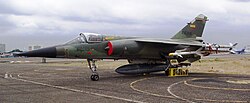
In response, the Ecuadorian Air Force (FAE) deployed Mirage F.1JA and IAI Kfir C.2 interceptors. During a clash on February 10, an A-37B was shot down by a Kfir. Ecuador claimed to have shot down two Peruvian Sukhoi Su-22s using Mirage fighters, though Peru disputed this, attributing the losses to anti-aircraft artillery and an engine fire.
Casualties and Material Losses
Estimating the human cost of the war remains difficult due to conflicting reports. Official figures cite a death toll of 94, while some human rights NGOs and senior officers suggest the total mortal casualties for both sides could be as high as 500. Material losses included several aircraft and helicopters from both nations.
| Belligerent | Official Deaths | Other Reported Deaths | Aircraft/Helicopters Lost |
|---|---|---|---|
| Peru | 60 | 50+ | 3 Helicopters (2 Mi-8T, 1 Mi-25), 4 Aircraft (2 Su-22, 1 A-37B, 1 Canberra) |
| Ecuador | 104 (Killed/Wounded) | 350 | 2 Aircraft (1 A-37B, 1 AT-33A) |
The Path to Peace
The military stalemate and the desire for a permanent solution led both nations back to the negotiating table. Brokered by the Rio Protocol guarantors, the process culminated in the Brasilia Presidential Act on October 26, 1998. Signed by Presidents Jamil Mahuad of Ecuador and Alberto Fujimori of Peru, the act definitively resolved the border dispute.
The agreement largely favored the Peruvian claim that the border followed the Cordillera del Cóndor line. However, as a symbolic gesture, Peru granted Ecuador 1 square kilometer of territory at Tiwinza (level 1061) as "private property." This land is reserved for commemorative and non-military acts, though sovereignty remains with Peru; consequently, anyone born in Tiwinza is considered a Peruvian citizen.
Controversies Regarding Armaments
Following the war, allegations surfaced regarding illegal arms sales. Peruvian reports claimed Chile sold weaponry to Ecuador during the conflict. While Chile initially denied this, later statements from former Ecuadorian Chief of Staff General Víctor Manuel Bayas and Colonel Ernesto Checa suggested that Chile, Argentina, and Russia provided ammunition and equipment during the fighting. The Chilean government maintained that any such transfers after a legal 1994 sale were illegal and not sanctioned by the state.
Frequently Asked Questions
What was the primary cause of the Alto Cenepa incident?
The conflict was caused by a long-standing dispute over the demarcation of the border in the Cordillera del Cóndor region, specifically regarding the interpretation and implementation of the 1942 Rio Protocol.
How was the conflict finally resolved?
The conflict was resolved through diplomatic negotiations brokered by Argentina, Brazil, Chile, and the United States, resulting in the signing of the Brasilia Presidential Act in 1998.
What is the status of Tiwinza today?
Tiwinza is a one-square-kilometer area of Peruvian territory granted to Ecuador as private property for non-military, commemorative purposes, without Ecuadorian sovereignty.
Which aircraft were involved in the aerial combat?
Key aircraft included the Peruvian Sukhoi Su-22 and A-37B, and the Ecuadorian Mirage F.1JA and IAI Kfir C.2.
When did the territorial dispute officially end?
The dispute effectively ended with the signing of the peace agreement in 1998 and the formal demarcation of the border on May 13, 1999.