
Cape Juby: A History of Territorial Shifts and Colonial Influence
The region of Cape Juby, located along the southern coast of Morocco, has served as a geopolitical focal point for centuries. From early diplomatic treaties between Moroccan Sultans and Spanish monarchs to the complexities of European colonial expansion, the area's history is marked by shifting boundaries and contested sovereignty.
Precolonial Era and Early Diplomacy
The diplomatic relationship between Morocco and Spain began to formalize in the late 18th century. On May 28, 1767, Sultan Mohammed ben Abdallah signed a peace and commerce treaty with King Charles III of Spain. A notable detail of this agreement was Article 18, in which Morocco admitted it could not guarantee the security of Spanish fishermen south of the Noun River, as the Moroccan state lacked control over the local Tekna tribes.
By the turn of the century, the scope of Moroccan sovereignty was further clarified. On March 1, 1799, Sultan Slimane signed an accord with King Charles IV of Spain. In Article 22 of this document, the Sultan recognized that the regions of Cape Juby and Saguia el-Hamra were not part of his dominions.
The British Presence at Port Victoria
In 1879, the British North West Africa Company expanded its reach by establishing a trading post near Cape Juby known as "Port Victoria." This presence was short-lived and volatile; on March 26, 1888, Moroccan soldiers attacked the post, resulting in the death of the post's director and injuries to two workers. The company eventually sold the post to the Sultan of Morocco in 1895.
The Spanish Protectorate
The early 20th century saw a shift toward formal European administration. In 1912, Spain negotiated concessions for the southern Moroccan coast with France, which was managing Moroccan affairs at the time. On July 29, 1916, Francisco Bens officially occupied the Cape Juby region for Spain.
Spain administered this territory as part of Spanish West Africa, a single administrative entity that included the Ifni enclave and Spanish Sahara. The region spanned 12,700 square miles (33,000 km2) and supported a population of 9,836 people.
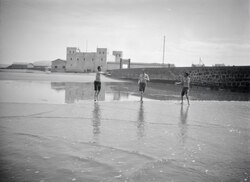
The Spanish established a primary town called Villa Bens, known today as Tarfaya. Beyond its administrative role, Villa Bens served as a critical staging post for airmail flights, linking the colony with other territories.
Retrocession to Morocco
Following Morocco's achievement of full independence in 1956, the new government sought the return of officially Moroccan territories held by Spain. This process was not entirely peaceful; the period of 1957 saw resistance and combat during the Ifni War.
Ultimately, the Spanish government yielded to these demands, and in 1958, the Cape Juby Strip was officially ceded back to Morocco.
Key Facts
- Total Area: 12,700 square miles (33,000 km2) under Spanish rule.
- Population: 9,836 residents during the Spanish protectorate.
- Key Settlement: Villa Bens (modern-day Tarfaya), used for airmail flights.
- Administrative Grouping: Part of Spanish West Africa, alongside Ifni and Spanish Sahara.
- Final Transition: Ceded to Morocco in 1958 following the Ifni War.
| Year | Event | Key Figure/Entity |
|---|---|---|
| 1767 | Peace and commerce treaty signed | Sultan Mohammed ben Abdallah & King Charles III |
| 1799 | Recognition that Cape Juby was not Moroccan dominion | Sultan Slimane & King Charles IV |
| 1879 | Establishment of Port Victoria trading post | British North West Africa Company |
| 1916 | Official Spanish occupation | Francisco Bens |
| 1958 | Retrocession of the Cape Juby Strip to Morocco | Spanish Government |
Frequently Asked Questions
What was Villa Bens?
Villa Bens was the main town founded by the Spanish in the Cape Juby region. It is known today as Tarfaya and historically served as a staging post for airmail flights.
Who controlled Cape Juby before the Spanish protectorate?
The area saw various influences, including a trading post established by the British North West Africa Company in 1879, which was later sold to the Sultan of Morocco in 1895.
What was Spanish West Africa?
Spanish West Africa was the administrative entity used by Spain to govern the Cape Juby region, the Ifni enclave, and Spanish Sahara as a single unit.
How did Cape Juby return to Moroccan control?
After Morocco gained independence in 1956, it requested the return of its territories. Following fighting during the Ifni War in 1957, Spain ceded the Cape Juby Strip to Morocco in 1958.
Why couldn't Morocco guarantee the security of Spanish fishermen in 1767?
According to the treaty signed by Sultan Mohammed ben Abdallah, Morocco did not have control over the Tekna tribes who inhabited the coasts south of the Noun River.