
Koh Rong: Geography and Natural Landscapes of Cambodia's Largest Island
Located in the Gulf of Thailand off the coast of Sihanoukville, Koh Rong stands as the largest island in the region. Characterized by its elongated shape stretching from the southeast to the northwest, the island covers a total area of 78 square kilometers (30 sq mi). From its dense interior forests to its diverse coastline, Koh Rong is a sanctuary of natural beauty and geological variety.
Key Facts
- Total Area: 78 km² (30 sq mi).
- Highest Point: A mountain reaching 316 m (1,037 ft) in the northwest.
- Coastline: Approximately 43 km (27 mi) of beaches.
- Beach Diversity: 23 distinct beaches with white, beige, and rose-colored sands.
- Administrative Region: Part of Sangkat Koh Rong (Commune 5) in the Mittakpheap District.
Terrain and Interior Landscapes
The topography of Koh Rong is predominantly hilly, anchored by a significant mountain in the northwest that peaks at 316 meters (1,037 ft). These elevations serve as vital watersheds, feeding numerous estuaries and creeks that carve through the landscape. The island's interior remains largely covered in dense forest, which hides several seasonal waterfalls.
Connecting the hilly massifs of the southeast and northwest is a central "belt" of sediments. This flat region contains a small savanna, a landscape feature resulting from human cultivation and activity, though the majority of the island's surface remains forested.
The Diverse Coastline and Marine Environment
Koh Rong is renowned for its 43 kilometers (27 mi) of delicate beaches. Along the coastline, visitors can find at least 23 different beaches, featuring a striking palette of sand colors ranging from classic white and beige to unique rose-colored hues. The scenic panorama is further enhanced by protruding capes, deep bays, and impressive sandstone rock formations.
The island's shores vary significantly by orientation. The southern coastline is exposed to the open sea and weather, creating a spectacular and rugged environment. In contrast, the eastern coast faces the mainland and is defined by smooth hills that slope gently toward crescent-shaped bays, inlets, and beaches.
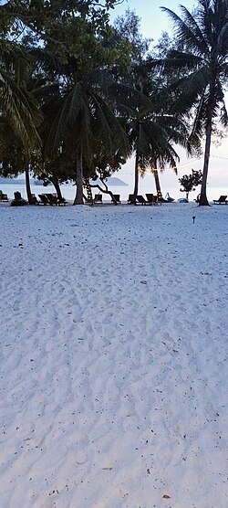
Surrounding the main island are several reefs and small islets. These features create a rich variety of natural habitats that support a wide array of marine life.
Regional Geography and Neighboring Islands
Koh Rong is part of a larger cluster of islands within the Mittakpheap District. To the southeast lies the tiny Koh Touch island, while the twin islands of Koh Bong-Po'own (also known as Koh Song-Saa) are located to the northeast. To the south, the uninhabited island of Koh Koun precedes the island of Koh Rong Sanloem.
Together, these five islands constitute the Sangkat Koh Rong, also known as Commune 5.
| Feature | Details |
|---|---|
| Total Area | 78 km² (30 sq mi) |
| Maximum Elevation | 316 m (1,037 ft) |
| Beach Length | ~43 km (27 mi) |
| Number of Beaches | 23+ |
| Sand Colors | White, Beige, Rose |
| Administrative Unit | Sangkat Koh Rong (Commune 5) |
Frequently Asked Questions
What is the highest point on Koh Rong?
The highest point is a mountain located in the northwest of the island, reaching an elevation of 316 meters (1,037 ft).
How many beaches are there on the island?
There are no fewer than 23 beaches along the coastline, varying in length and sand color.
What colors is the sand on Koh Rong's beaches?
The sand colors range from predominantly white to beige and even rose-colored.
Which islands make up Sangkat Koh Rong?
Sangkat Koh Rong (Commune 5) consists of five islands: Koh Rong, Koh Touch, Koh Bong-Po'own (Koh Song-Saa), Koh Koun, and Koh Rong Sanloem.
What is the terrain like in the center of the island?
The center of the island features a flat belt of sediments that connects the southeast and northwest hilly regions, containing a small savanna created by human activity.