
Long Island Barrier Islands
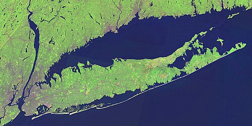
The south shore of Long Island is defined by a series of barrier islands—narrow strips of land that separate the mainland from the open Atlantic Ocean. These islands act as natural buffers, protecting the coast from storm surges and creating calm bays. From the urban fringes of New York City to the serene shores of Southampton, these islands have been shaped by both human engineering and the raw power of nature.
Historically, the westernmost section included Coney Island, Plumb Beach, Barren Island, and various smaller islands within Jamaica Bay. While Coney Island was once the westernmost barrier island, many of these landmasses were merged or connected to the mainland during the early 20th century.
Long Beach Barrier Island
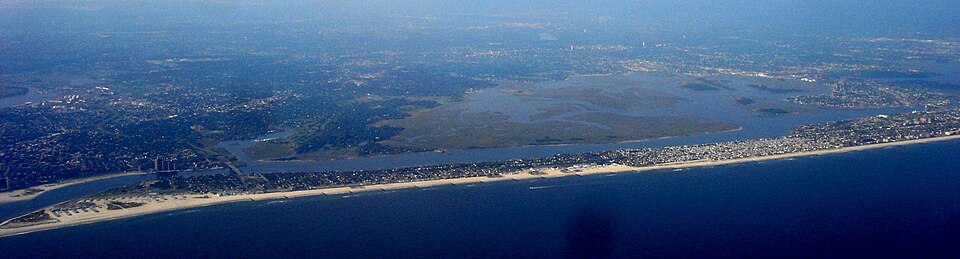
Located off the south shore of Long Island, the Long Beach Barrier Island is divided among several communities. The hamlet of Atlantic Beach occupies the west, while the city of Long Beach and the hamlet of Lido Beach sit in the center. The eastern end is home to the hamlet of Point Lookout. Atlantic Beach, Lido Beach, and Point Lookout are all part of the town of Hempstead.
The city of Long Beach is unique in that it spans the entire width of the island, bordering Reynolds Channel to the north and the Atlantic Ocean to the south. Connectivity to the mainland is maintained via the Long Beach Bridge (connecting to Island Park) and the Atlantic Beach Bridge (connecting to Lawrence). Additionally, the Loop Parkway provides a link from the border of Lido Beach and Point Lookout to Jones Beach.
Jones Beach Island
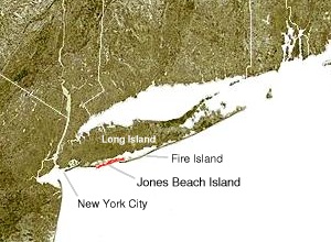
Jones Beach Island, sometimes called Oak Beach Island, is named after the father of historian Thomas Jones. Separated from the mainland by the Great South Bay, this island straddles the border between Nassau and Suffolk counties and includes the census-designated places of Gilgo, Oak Beach, and Captree.
The island is a major recreational hub, most notably featuring Jones Beach State Park on its western tip. Access is provided via three main parkways: the Meadowbrook, Loop, and Wantagh Parkways. To the east, the Robert Moses Causeway—incorporating the Great South Bay Bridge and the State Boat Channel Bridge—links the island to Babylon and Fire Island. The Ocean Parkway runs the full length of the island, connecting these causeways.
Fire Island
Fire Island is a slender barrier island stretching approximately 31 miles (50 km) in length, with a width varying between 0.1 and 0.25 miles. Located in southern Suffolk County, it is separated from the mainland by the Great South Bay. The island covers a land area of 8.687 square miles.
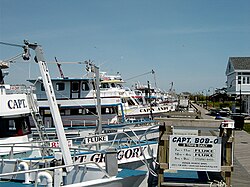
While the permanent population was reported as 491 in the 2000 census, the island hosts hundreds of thousands of seasonal visitors. The island consists of three Census Bureau-defined communities, the largest being the unincorporated Fire Island CDP. Other notable oceanfront communities include Davis Park and Watch Hill, as well as the villages of Saltaire and Ocean Beach. Access to these communities is limited to private boats or seasonal ferries.
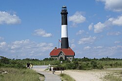
The Fire Island Inlet
The Fire Island Inlet connects the Great South Bay to the Atlantic Ocean, situated between Robert Moses State Park and Captree State Park. This inlet is a product of longshore drift—the process by which ocean currents move sediment along the coast. This natural evolution has shifted the landscape significantly; for example, the Fire Island Light, built in 1858 at the mouth of the inlet, is now located six miles to the east.
Westhampton Island
Westhampton Island is the easternmost outer barrier island in the Town of Southampton. Its creation was the result of severe weather events: a 1931 nor'easter created the Moriches Inlet, separating it from Fire Island, and the 1938 New England hurricane created the Shinnecock Inlet, officially forming Westhampton Island. The western end of the island is home to Cupsogue Beach County Park.
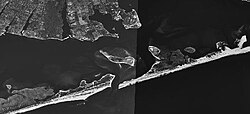
Major Inlets and Geographic Oddities
The Moriches Inlet connects Moriches Bay to the Atlantic. Its formation created a jurisdictional anomaly where the Town of Brookhaven owns land west of West Hampton Dunes, yet accessing that land requires a nearly 20-mile drive through the Town of Southampton.
The Shinnecock Inlet, the easternmost of five major inlets, was formed during the Great Hurricane of 1938. It aligns with the Shinnecock Canal, providing a shortcut for boaters traveling to the Atlantic. While dredging is maintained to keep the inlet open, this practice remains controversial due to its contribution to beach erosion on Fire Island.
Key Facts
- Fire Island Dimensions: Approximately 31 miles long and 0.1 to 0.25 miles wide.
- Formation: Westhampton Island was created by a 1931 nor'easter and the 1938 New England hurricane.
- Connectivity: Jones Beach Island is accessible via the Meadowbrook, Loop, and Wantagh Parkways.
- Natural Processes: Longshore drift has moved the Fire Island Light 6 miles away from the inlet since 1858.
- Geography: The Great South Bay separates the mainland of Long Island from several of its barrier islands.
| Island Name | Key Features/Communities | Primary Access/Connections |
|---|---|---|
| Long Beach | Atlantic Beach, Long Beach, Lido Beach, Point Lookout | Long Beach Bridge, Atlantic Beach Bridge, Loop Parkway |
| Jones Beach | Jones Beach State Park, Gilgo, Oak Beach, Captree | Meadowbrook, Loop, and Wantagh Parkways; Robert Moses Causeway |
| Fire Island | Saltaire, Ocean Beach, Davis Park, Watch Hill | Private boat, seasonal ferry |
| Westhampton | Cupsogue Beach County Park | Boat access via Moriches and Shinnecock Inlets |
Frequently Asked Questions
How was Westhampton Island formed?
Westhampton Island was created through two major weather events: a nor'easter in 1931 that created the Moriches Inlet and the Great Hurricane of 1938 that created the Shinnecock Inlet.
What is longshore drift and how did it affect Fire Island?
Longshore drift is the natural movement of sediment along a coastline by ocean currents. On Fire Island, this process has shifted the inlet's position, moving the Fire Island Light six miles east of the inlet since its construction in 1858.
How do people reach the communities on Fire Island?
Because there are no bridges to the mainland, Fire Island's communities are accessible only via private boats or seasonal ferry services.
What is the jurisdictional oddity regarding the Moriches Inlet?
The creation of the Moriches Inlet resulted in the Town of Brookhaven having jurisdiction over land west of West Hampton Dunes, despite the fact that the only land access to that area requires driving nearly 20 miles through the Town of Southampton.
Which parkways provide access to Jones Beach Island?
Jones Beach Island can be reached via the Meadowbrook Parkway (to Merrick), the Loop Parkway (to Long Beach), and the Wantagh Parkway (to Wantagh).