
Macquarie Fault Zone: Tectonic Evolution and Plate Dynamics
The Macquarie Fault Zone is a complex tectonic boundary where the Pacific and Indo-Australian plates interact. This region is characterized by a transition from ancient seafloor spreading to modern convergence, creating a diverse landscape of ridges, trenches, and fault systems that stretch toward the South Island of New Zealand.
At its northern extent, the zone merges into the Alpine Fault, which cuts across the continental crust of New Zealand. Currently, the northern and southern ends of the zone are converging at a rate of between 2 and 4 cm per year. This interaction is not purely lateral; it includes a component of convergence that increases as the boundary approaches New Zealand.
Key Facts
- Current Convergence: The zone moves at 2 to 4 cm per year.
- Plate Interaction: Involves the Pacific plate and the Indo-Australian plate (including the Macquarie microplate).
- Historical Origin: Oceanic crust was generated via seafloor spreading starting approximately 40 million years ago.
- Tectonic Shift: The region has transitioned from a divergent boundary (spreading) to a transform and incipient subduction zone.
- Key Features: Includes the Macquarie Ridge, Puysegur Trench, and Hjort Trench.
The Evolution of the Macquarie Ridge
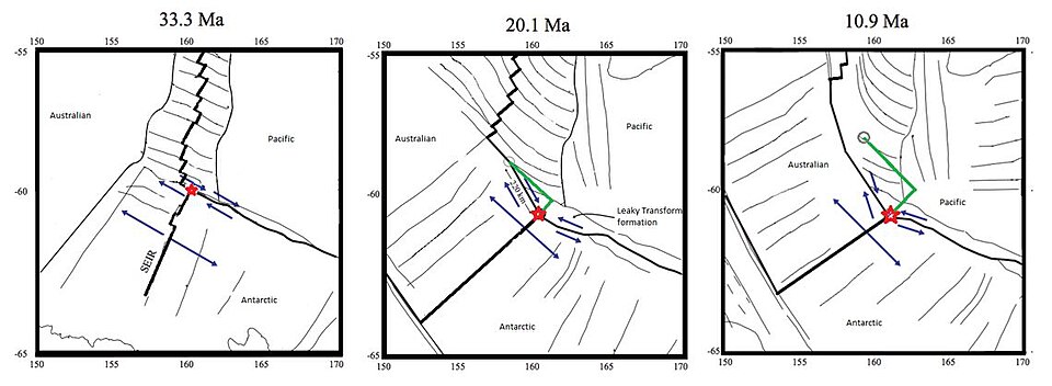
The Macquarie Ridge is an extinct mid-ocean ridge system that has undergone complex tectonic processes over the last 30 million years. Originally a site of seafloor spreading, it has evolved into the current Australian-Pacific plate boundary. This process of tectonic inversion—where a divergent boundary becomes convergent—has been gradual, leading to localized transpression (a combination of strike-slip and compression) and compression over 10 to 15 million years.
The timeline of this evolution began approximately 42 million years ago with the opening of the South East Tasman (Macquarie) Basin, caused by the separation of the Campbell Plateau and Resolution Ridge.
The Cessation of Seafloor Spreading
As the relative motion between the Pacific and Australian plates became too oblique to sustain extension, magmatism and seafloor spreading ceased. This shutdown did not happen simultaneously across the ridge but propagated from south to north:
- Southern regions: Spreading stopped around 25.9 million years ago.
- Central segments: Spreading ceased by 10 million years ago, specifically in the segment containing Macquarie Island.
- Northern regions: Spreading may have continued as recently as 1.6 million years ago, though some evidence suggests it stopped between 5 and 1.6 million years ago.
Modern Tectonic Structures
Today, the plate boundary is located along the crests of the ridges rather than in the troughs, with a deformation zone reaching up to 100 km in width. Since spreading stopped 10 million years ago in the central area, there has been a right lateral displacement of up to 290 km.
The Macquarie Microplate
Recent tectonic modeling identifies the Macquarie microplate, a section of the Indo-Australian plate that began rotating independently 6.24 million years ago. While there is evidence of a diffuse zone of deformation caused by compression between this microplate and the Australian plate, this area is not currently seismologically active.
Incipient Subduction Zones
Researchers view the fault zone as an incipient subduction zone, where lateral strike-slip motion is transitioning into subduction. This is evident in two primary areas:
- Puysegur Trench: Here, the Indo-Australian plate is beginning to sink beneath the Pacific plate.
- Hjort Trench: In the far south, subduction may be initiating. This is considered atypical because lighter oceanic crust from the Southeast Indian Ridge is subducting under heavier oceanic crust from the extinct Australia-Pacific spreading center.
Tectonic Summary Table
| Time Period | Tectonic Event | Key Feature/Location |
|---|---|---|
| ~47.91 Million Years Ago | Creation of the Macquarie triple junction | Regional Boundary |
| ~42 Million Years Ago | Opening of South East Tasman Basin | Campbell Plateau & Resolution Ridge |
| ~30 Million Years Ago | Shift to oblique spreading | Macquarie mid-ocean ridge |
| 25.9 to 1.6 Million Years Ago | Cessation of seafloor spreading (South to North) | Entire Ridge System |
| 6.24 Million Years Ago | Independent rotation begins | Macquarie microplate |
| Present | Convergence and incipient subduction | Puysegur and Hjort Trenches |
Frequently Asked Questions
What is the current rate of convergence in the Macquarie Fault Zone?
The northern and southern ends of the zone are currently converging at a rate of between 2 and 4 cm per year.
How does the Hjort Trench differ from normal subduction?
Subduction at the Hjort Trench is atypical because lighter oceanic crust from the Southeast Indian Ridge is being forced under heavier oceanic crust from the extinct Australia-Pacific spreading center, which is the reverse of standard subduction patterns.
What is the Macquarie microplate?
The Macquarie microplate is a portion of the Indo-Australian plate that began rotating independently of the main Australian plate approximately 6.24 million years ago.
When did seafloor spreading stop in the central Macquarie segment?
Seafloor spreading in the central segment, which includes Macquarie Island, ceased approximately 10 million years ago.
What is the relationship between the Macquarie Fault Zone and the Alpine Fault?
The Macquarie Fault Zone extends northward and merges into the Alpine Fault, which cuts across the continental crust of New Zealand's South Island.