
NY 25: A Comprehensive History of Long Island's Arterial Route
New York State Route 25 (NY 25) serves as a vital transportation artery across Long Island, evolving over a century from a series of disconnected state-maintained roads into a complex highway system. Its history is a reflection of the region's growth, shifting from rural paths to high-volume urban boulevards that connect the heart of Manhattan to the eastern reaches of Orient Point.
Key Facts
- Origin: Assigned in 1924, originally following the path of modern NY 25A east of the NYC line.
- Extent: Eventually extended west into Manhattan (1934) and east to Orient Point (c. 1932).
- Major Segments: Includes well-known stretches such as Jericho Turnpike, Middle Country Road, and Queens Boulevard.
- Traffic Volume: By the 1960s, Queens Boulevard handled over 85,000 vehicles daily.
- Modern Updates: Recent infrastructure includes offset bus lanes in Jamaica implemented in 2025.
Early Development and Realignment (1924–1934)
The designation of NY 25 began in 1924. Initially, the route covered what is now NY 25A east of the New York City line, continuing to Greenport. During this era, the section between the city line and Smithtown was maintained by the state but remained unnumbered until it became NY 25A around 1927.
Significant shifts occurred in 1929 when NY 25 was realigned to follow Jericho Turnpike and Middle Country Road between Smithtown and Riverhead. This change pushed the former northern alignment into the NY 25A designation. By the 1930 renumbering of state highways, the routings of NY 25 and NY 25A were flipped west of Smithtown to establish their current paths.
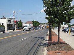
Expansion to the East and West
Around 1932, the route was extended eastward to reach Orient Point. In mid-December 1934, NY 25 became one of the first routes signed within New York City limits. This extension took the route through Jericho Turnpike, Braddock Avenue, Springfield Boulevard, and Horace Harding Boulevard, eventually joining NY 24 at Queens Boulevard.
At that time, NY 25 overlapped with NY 24 and NY 25A across the Queensboro Bridge into Manhattan, terminating at Park Avenue (then NY 22 and NY 100).
Urban Evolution in Queens
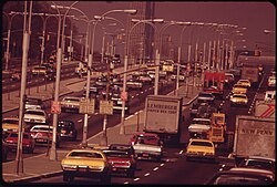
Between 1938 and 1970, NY 25 underwent several alignment changes in Queens to optimize traffic flow. In 1938, it was realigned to follow Queens Boulevard from Skillman Avenue to Horace Harding Boulevard. By 1940, it shifted further south via Union Turnpike.
The Freeway Proposal and Traffic Management
In 1941, the New York City Planning Department proposed converting Queens Boulevard into a freeway (a divided highway with controlled access) similar to the Van Wyck Expressway. While some express lanes were depressed near Woodhaven and Horace Harding Boulevards, World War II delayed the project, and it was never fully completed.
To combat congestion, the Traffic Commission introduced the "triple-offset system" on February 1, 1950. This retiming of traffic signals favored westbound traffic during morning rush hour (7–9 a.m.) and eastbound traffic in the evening (5–7 p.m.). At the time, the boulevard averaged 73,000 cars per weekday.
Safety and Infrastructure Upgrades
By the 1960s, Queens Boulevard was the city's second busiest roadway, trailing only the Long Island Expressway. Despite proposals by Borough President John T. Clancy to reconstruct the boulevard for the 1964 World's Fair, bureaucratic hurdles limited the project to a 2.5-mile section. Improvements included yellow asphalt surfacing to guide turns and narrowed malls to widen the roadway.
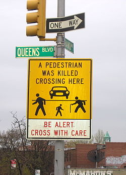
Safety became a primary focus in 1985 when the NYCDOT investigated high fatality rates. By adjusting signal timing to increase pedestrian crossing times, deaths in Forest Hills and Rego Park dropped from an average of four per year (1980–1984) to one in 1986.
Regional Changes and Modern Alignments
The route's relationship with Manhattan shifted over time. Overlaps with NY 24 and NY 25A were removed by 1964, and the route was eventually truncated to end in Queens in 1967. However, it was re-extended across the Queensboro Bridge to FDR Drive on January 1, 1970.
Infrastructure in Eastern Long Island
In Riverhead, the completion of I-495 led to a fully operational interchange with CR 58 by 1972, featuring high-speed banked curves and grade-separated ramps. Other proposed upgrades included frontage roads between Nesconset and Lake Grove and the widening of NY 25 in Coram.
Naming Conventions and Legacy Roads
A long-standing naming confusion existed at the New York City and Nassau County border, where the road was simultaneously called Jamaica Avenue (westbound) and Jericho Turnpike (eastbound). This was resolved by legislation signed by Mayor Michael Bloomberg on June 6, 2005, renaming the westbound side Jericho Turnpike.
Many "Old" segments of the road still exist, serving as historical markers of previous alignments. These include Old Jericho Turnpike, Old Middle Country Road, and various sections of Old Main Road in Mattituck, Southold, and Orient.
| Year | Event/Change | Impact |
|---|---|---|
| 1924 | Initial Assignment | Route established east of NYC line to Greenport. |
| 1934 | NYC Extension | Route extended west into Manhattan via Queensboro Bridge. |
| 1950 | Triple-Offset System | Traffic signals retimed to reduce peak congestion. |
| 1967 | Truncation | Route terminus moved from Manhattan back to Queens. |
| 2005 | Naming Legislation | Westbound side renamed Jericho Turnpike at the county line. |
| 2025 | Bus Lane Update | Offset bus lanes installed in Jamaica. |
Frequently Asked Questions
Why was the Queens Boulevard freeway project never finished?
The plan to convert Queens Boulevard into a freeway with grade separation was delayed by the onset of World War II and was ultimately never completed.
What was the "triple-offset system"?
It was a traffic signal retiming strategy implemented in 1950 to speed up traffic by favoring westbound vehicles in the morning and eastbound vehicles in the evening.
How was the naming conflict at the Nassau County border resolved?
In 2005, Mayor Michael Bloomberg signed legislation that renamed the westbound side of NY 25 between Braddock Avenue and the Nassau County line as Jericho Turnpike, ending the split naming with Jamaica Avenue.
What are "Old" segments of NY 25?
These are former alignments of the highway that were bypassed during widening or straightening projects. Examples include Old Main Road and Old Middle Country Road, many of which remain intact today.
How did NY 25 improve pedestrian safety in the 1980s?
The NYCDOT increased pedestrian crossing times at traffic signals, which helped reduce average annual pedestrian deaths in the Forest Hills and Rego Park sections from four to one.